
Malung topographic map
Interactive map
Click on the map to display elevation.
About this map
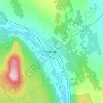
Name: Malung topographic map, elevation, terrain.
Location: Malung, Malung-Sälens kommun, Dalarna County, 782 31, Sweden (60.64645 13.67459 60.72645 13.75459)
Average elevation: 341 m
Minimum elevation: 292 m
Maximum elevation: 500 m
Other topographic maps
Click on a map to view its topography, its elevation and its terrain.