
Cornwallis Island topographic map
Interactive map
Click on the map to display elevation.
About this map
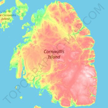
Name: Cornwallis Island topographic map, elevation, terrain.
Location: Cornwallis Island, Nunavut, X0A 0V0, Canada (74.62758 -96.62591 75.64367 -93.38890)
Average elevation: 73 m
Minimum elevation: -2 m
Maximum elevation: 361 m
Nunavut trails, hiking, mountain biking, running and outdoor activities
Other topographic maps
Click on a map to view its topography, its elevation and its terrain.
Mount Odin
Canada > Nunavut > Qikiqtaaluk Region
Mount Odin is the highest mountain within the Baffin Mountains as well as the fifth-highest in the Arctic Cordillera. It has a topographic prominence of 2,147 m (7,044 ft), greater than any other mountain within the Baffin Mountains and on Baffin Island, making Odin the third-highest mountain in Nunavut by…
Average elevation: 1,440 m
Iqaluit
Iqaluit has a tundra climate (Köppen: ET) typical of the Arctic region, although it is well outside the Arctic Circle. The city features long, cold winters and brief, cool summers. Average monthly temperatures are below freezing for eight months of the year. Iqaluit averages just over 400 mm (16 in) of…
Average elevation: 51 m
Arctic Bay
Canada > Nunavut > Qikiqtaaluk Region
Arctic Bay experiences a tundra climate (Köppen: ET) like most northern Canadian territories at low elevations, with long, very cold winters and short, cool to cold summers. July is the only month with an average low temperature above freezing. Its climate does not differ from the more severe subarctic…
Average elevation: 160 m
Iqaluit
Iqaluit has a tundra climate (Köppen: ET) typical of the Arctic region, although it is well outside the Arctic Circle. The city features long, cold winters and brief, cool summers. Average monthly temperatures are below freezing for eight months of the year. Iqaluit averages just over 400 mm (16 in) of…
Average elevation: 50 m
Mount Thor
Canada > Nunavut > Qikiqtaaluk Region
Mount Thor, officially gazetted as Thor Peak (Inuktitut: ᙯᕐᓱᐊᓗᒃ Qaisualuk "huge bedrock"[3][4] or Inuktitut: ᑭᒍᑎᙳᐊᖅ Kigutinnguaq "tooth-like"[3][5]), is a mountain with an elevation of 1,675 m (5,495 ft) located in Auyuittuq National Park, on Baffin Island, Nunavut, Canada. The mountain…
Average elevation: 802 m
Arctic Bay
Canada > Nunavut > Qikiqtaaluk Region
Arctic Bay experiences a tundra climate (Köppen: ET) like most northern Canadian territories at low elevations, with long, very cold winters and short, cool to cold summers. July is the only month with an average low temperature above freezing. Its climate does not differ from the more severe subarctic…
Average elevation: 137 m