Geolocate

Rankin Inlet topographic map

Click on the map to display elevation.

About this map

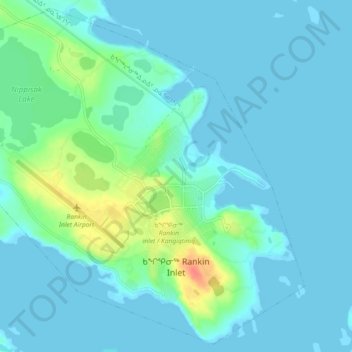
Name: Rankin Inlet topographic map, elevation, terrain.

Location: Rankin Inlet, Kivalliq Region, Nunavut, Canada (62.79384 -92.14474 62.83368 -92.05341)

Average elevation: 8 m

Minimum elevation: -1 m

Maximum elevation: 46 m

Kivalliq Region trails, hiking, mountain biking, running and outdoor activities

Other topographic maps

Click on a map to view its topography, its elevation and its terrain.

Nunalla

Canada > Nunavut > Kivalliq Region

Average elevation: 1 m

Whale Cove

Canada > Nunavut > Kivalliq Region

Average elevation: 5 m

Baker Lake

Canada > Nunavut > Kivalliq Region

Average elevation: 50 m

Gear up for your next adventure:

🥾Hiking Gaiters - Protect legs and shoes from mud, snow, and debris
🧤Rechargeable Heated Gloves - Extreme warmth for Canadian winter expeditions
🥤Collapsible Travel Cup - Saves space and weight in your mess kit
🔥Emergency Fire Starter - Reliable ignition source for all weather conditions
💧Collapsible Water Bottle - Space-saving water bottle for outdoor activities

As an Amazon Associate, this site earns from qualifying purchases at no extra cost to you.