
Coral Harbour topographic map
Interactive map
Click on the map to display elevation.
About this map
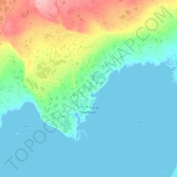
Name: Coral Harbour topographic map, elevation, terrain.
Location: Coral Harbour, Kivalliq Region, Nunavut, X0C 0C0, Canada (64.09724 -83.46343 64.21209 -83.11294)
Average elevation: 24 m
Minimum elevation: 0 m
Maximum elevation: 115 m
Kivalliq Region trails, hiking, mountain biking, running and outdoor activities
Other topographic maps
Click on a map to view its topography, its elevation and its terrain.