
Arctic Bay topographic map
Interactive map
Click on the map to display elevation.
About this map
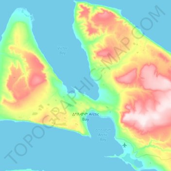
Name: Arctic Bay topographic map, elevation, terrain.
Location: Arctic Bay, Qikiqtaaluk Region, Nunavut, Canada (72.97645 -85.41647 73.15006 -84.91642)
Average elevation: 137 m
Minimum elevation: 0 m
Maximum elevation: 577 m
Arctic Bay experiences a tundra climate (Köppen: ET) like most northern Canadian territories at low elevations, with long, very cold winters and short, cool to cold summers. July is the only month with an average low temperature above freezing. Its climate does not differ from the more severe subarctic climates except for the practically non-existent summer (even Svalbard, an island to the north, has much warmer summers). Even in summer, the average temperature at dawn can be below freezing. The amount of precipitation is of a desert climate, below 250 mm (9.8 in), and the days of snow is comparable to a coastal city of a lake or sea in the middle latitudes, but low for the location. Most precipitation is between summer and early fall. With the thawing process of permafrost, some communities such as Arctic Bay may be affected by flooding due to the melting of sea ice and erosion due to the mechanical process of temperature changes and their own variation.
Other topographic maps
Click on a map to view its topography, its elevation and its terrain.
Qikiqtarjuaq
Canada > Nunavut > Qikiqtaaluk Region
Qikiqtarjuaq, Qikiqtaaluk Region, Nunavut, Canada
Average elevation: 138 m
Pond Inlet (Mittimatalik)
Canada > Nunavut > Qikiqtaaluk Region
Pond Inlet (Mittimatalik), Qikiqtaaluk Region, Nunavut, Canada
Average elevation: 82 m
Kimmirut
Canada > Nunavut > Qikiqtaaluk Region
Kimmirut, Qikiqtaaluk Region, Nunavut, Canada
Average elevation: 85 m
Arctic Bay
Canada > Nunavut > Qikiqtaaluk Region
Arctic Bay, Qikiqtaaluk Region, Nunavut, Canada
Average elevation: 160 m
Flaherty Island
Canada > Nunavut > Qikiqtaaluk Region
Flaherty Island, Qikiqtaaluk Region, Nunavut, X0A 0W0, Canada
Average elevation: 8 m
Cape Dyer
Canada > Nunavut > Qikiqtaaluk Region
Cape Dyer, Qikiqtaaluk Region, Nunavut, Canada
Average elevation: 537 m
Resolute Bay
Canada > Nunavut > Qikiqtaaluk Region > Resolute > Resolute
Resolute Bay, Resolute, Qikiqtaaluk Region, Nunavut, Canada
Average elevation: 5 m
Cape Dorset
Canada > Nunavut > Qikiqtaaluk Region
Cape Dorset, Qikiqtaaluk Region, Nunavut, X0A 0C0, Canada
Average elevation: 38 m
Mount Thor
Canada > Nunavut > Qikiqtaaluk Region
Mount Thor, Qikiqtaaluk Region, Nunavut, Canada
Average elevation: 802 m
Round Island
Canada > Nunavut > Qikiqtaaluk Region
Round Island, Qikiqtaaluk Region, Nunavut, Canada
Average elevation: 78 m
Cumberland Sound
Canada > Nunavut > Qikiqtaaluk Region
Cumberland Sound, Qikiqtaaluk Region, Nunavut, Canada
Average elevation: 0 m
Hall Beach
Canada > Nunavut > Qikiqtaaluk Region > Hall Beach
Hall Beach, Qikiqtaaluk Region, Nunavut, Canada
Average elevation: 2 m
Igloolik
Canada > Nunavut > Qikiqtaaluk Region
Igloolik, Qikiqtaaluk Region, Nunavut, X0A 0L0, Canada
Average elevation: 5 m
Eureka
Canada > Nunavut > Qikiqtaaluk Region
Eureka, Qikiqtaaluk Region, Nunavut, Canada
Average elevation: 160 m
Resolute
Canada > Nunavut > Qikiqtaaluk Region
Resolute, Qikiqtaaluk Region, Nunavut, X0A 0V0, Canada
Average elevation: 82 m
Pangnirtung
Canada > Nunavut > Qikiqtaaluk Region
Pangnirtung, Qikiqtaaluk Region, Nunavut, Canada
Average elevation: 342 m
Sanikiluaq
Canada > Nunavut > Qikiqtaaluk Region
Sanikiluaq, Qikiqtaaluk Region, Nunavut, X0A 0W0, Canada
Average elevation: 15 m
Port Burwell
Canada > Nunavut > Qikiqtaaluk Region
Port Burwell, Qikiqtaaluk Region, Nunavut, Canada
Average elevation: 28 m
Canadian Forces Station Alert
Canada > Nunavut > Qikiqtaaluk Region
Canadian Forces Station Alert, Qikiqtaaluk Region, Nunavut, Canada
Average elevation: 31 m
Amherst Island
Canada > Nunavut > Qikiqtaaluk Region
Amherst Island, Qikiqtaaluk Region, Nunavut, Canada
Average elevation: 27 m