
Red Sea topographic map
Interactive map
Click on the map to display elevation.
About this map
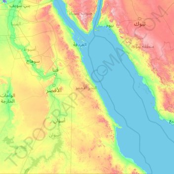
Name: Red Sea topographic map, elevation, terrain.
Location: Red Sea, Egypt (21.99367 31.78811 29.13873 37.11535)
Average elevation: 336 m
Minimum elevation: -21 m
Maximum elevation: 2,519 m
Other topographic maps
Click on a map to view its topography, its elevation and its terrain.
New Cairo City
Located in what was formerly Helwan Governorate, and located to the east of Maadi and Heliopolis, New Cairo ranges in elevation between 250 and 307 metres (820 and 1,007 ft) above sea level.
Average elevation: 227 m
New Cairo City
New Cairo is built in the Eastern Desert to the east of the Cairo Ring Road and the modern 1950s extension of Nasr City, on a plateau that ranges in elevation between 250 and 307 metres (820 and 1,007 ft) above sea level. It was created to comprise three towns (The First, Third, and Fifth settlements),…
Average elevation: 227 m
Saint Catherine
Köppen-Geiger climate classification system classifies the climate as desert (BWh). Saint Catherine has the coldest nights of any city in Egypt, and its humidity is very low. The highest mountain ranges in Egypt surround the town, with many smaller valleys leading from the basin to the mountains in all…
Average elevation: 1,472 m