Geolocate

Giza Pyramids topographic map

Click on the map to display elevation.

About this map

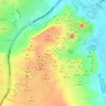
Name: Giza Pyramids topographic map, elevation, terrain.

Location: Giza Pyramids, Giza, Egypt (29.95452 31.10702 29.98702 31.14313)

Average elevation: 65 m

Minimum elevation: 17 m

Maximum elevation: 126 m

Gear up for your next adventure:

🧭GPS Handheld Device - Reliable GPS navigation for outdoor adventures
🛶Canoe Life Vest - Safety vest for water sports
Lightweight Backpacking Tent - Compact tent for efficient hiking trips
🔨Vehicle Emergency Tool - Safety tool for remote road trips to trailheads
🥾Waterproof Trail Shoes - Shoes designed to handle wet terrain

As an Amazon Associate, this site earns from qualifying purchases at no extra cost to you.