Geolocate

Sinnuris topographic map

Click on the map to display elevation.

About this map

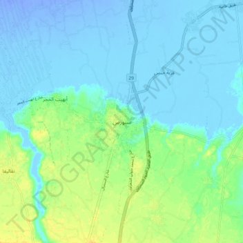
Name: Sinnuris topographic map, elevation, terrain.

Location: Sinnuris, Faiyum, 63748, Egypt (29.37366 30.82805 29.45366 30.90805)

Average elevation: 1 m

Minimum elevation: -34 m

Maximum elevation: 22 m

Other topographic maps

Click on a map to view its topography, its elevation and its terrain.

First Al Nagarin

Egypt > Faiyum

Average elevation: 23 m

Wadi Al Rayyan National Park

Egypt > Faiyum

Average elevation: 47 m

Faiyum Oasis

Egypt > Faiyum

Average elevation: 32 m

Watermelon Valley

Egypt > Faiyum

Average elevation: -15 m

First Al Nagarin

Egypt > Faiyum

Average elevation: 23 m

Youssef Al Sediq City

Egypt > Faiyum

Average elevation: 7 m

الكعابي الجديدة

Egypt > Faiyum

Average elevation: 19 m

New Al Fayoum City

Egypt > Faiyum

Average elevation: 59 m

Lake Qaroun

Egypt > Faiyum

Average elevation: 33 m

Youssef Al Sediq City

Egypt > Faiyum

Average elevation: 7 m

Gear up for your next adventure:

🥾Hiking Gaiters - Protect legs and shoes from mud, snow, and debris
🦶Hiking Shoe Insoles - Added support for high arches and long days on feet
🧥Thermal Fleece Jacket - Versatile insulation for changing mountain temperatures
🧥Insulated Jacket - Keep warm in cold outdoor conditions
Tent Footprint - Protect tent floor and increase durability

As an Amazon Associate, this site earns from qualifying purchases at no extra cost to you.