Geolocate

Sharm El Sheikh topographic map

Click on the map to display elevation.

About this map

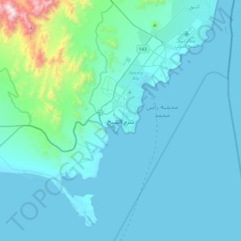
Name: Sharm El Sheikh topographic map, elevation, terrain.

Location: Sharm El Sheikh, Ras Umm Sid, South Sinai, 46619, Egypt (27.70444 34.13545 28.02444 34.45545)

Average elevation: 135 m

Minimum elevation: 0 m

Maximum elevation: 1,535 m

Other topographic maps

Click on a map to view its topography, its elevation and its terrain.

Abu Galum Protectorate

Egypt > South Sinai

Average elevation: 632 m

Al Tour City

Egypt > South Sinai

Average elevation: 50 m

Ras Muhammad National Park

Egypt > South Sinai

Average elevation: 112 m

Ras Sudr

Egypt > South Sinai

Average elevation: 17 m

Wadi Khuraytah

Egypt > South Sinai > Saint Catherine

Average elevation: 1,323 m

Ras Sudr

Egypt > South Sinai

Average elevation: 17 m

Gear up for your next adventure:

🔦LED Headtorch - Bright and durable light for night activities
🥾Waterproof Trail Shoes - Shoes designed to handle wet terrain
🥾Approach Boots - Comfortable boots for hiking and climbing approaches
🥾Trail Running Boots - Durable shoes designed for trail running
🔥Emergency Fire Starter - Reliable ignition source for all weather conditions

As an Amazon Associate, this site earns from qualifying purchases at no extra cost to you.