Geolocate

The Crossing topographic map

Click on the map to display elevation.

About this map

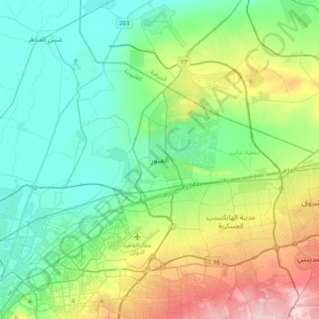
Name: The Crossing topographic map, elevation, terrain.

Location: The Crossing, Al Qalyubiya, 11785, Egypt (30.03140 31.29055 30.35140 31.61055)

Average elevation: 98 m

Minimum elevation: 2 m

Maximum elevation: 366 m

Other topographic maps

Click on a map to view its topography, its elevation and its terrain.

Bahada

Egypt > Al Qalyubiya

Average elevation: 16 m

Al Salam First

Egypt > Al Qalyubiya

Average elevation: 31 m

Akyad Digawy

Egypt > Al Qalyubiya

Average elevation: 15 m

El Obour

Egypt > Al Qalyubiya

Average elevation: 78 m

El Moushir Ahmed Ismail

Egypt > Al Qalyubiya

Average elevation: 71 m

Gear up for your next adventure:

🥾Hiking Leggings - Comfortable leggings for outdoor activities
🛶Waterproof Dry Bags - Keep electronics and clothes dry during river crossings
🥾Mountain Hiking Boots - High-traction boots for rocky terrain
🦯Trekking Poles - Reduced impact on joints for steep topographic climbs
🧰Emergency Multi-Tool - Compact multi-tool for outdoor survival

As an Amazon Associate, this site earns from qualifying purchases at no extra cost to you.