
Forsyth County topographic map
Interactive map
Click on the map to display elevation.
Forsyth County
The northeast section of Forsyth County, including Belews Creek and parts of Rural Hall, Walkertown, and Kernersville, is drained by tributaries of the Dan River. A small portion of Kernersville is in the Cape Fear River basin. Most of the county is drained by tributaries of the Yadkin River, which forms the western boundary of the county. The lowest elevation in the county is 660 feet, on the Yadkin River at the southwest corner of the county. The highest is 1100 feet, at a point just off Jefferson Church Road on the outskirts of King, immediately south of the county line.
About this map
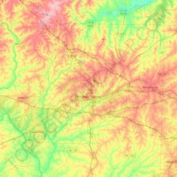
Name: Forsyth County topographic map, elevation, terrain.
Location: Forsyth County, North Carolina, United States (35.97277 -80.51669 36.26151 -80.03512)
Average elevation: 258 m
Minimum elevation: 174 m
Maximum elevation: 348 m
Other topographic maps
Click on a map to view its topography, its elevation and its terrain.
Arden
United States > North Carolina > Buncombe County > Asheville > Royal Pines
Average elevation: 693 m
Chimney Rock
United States > North Carolina > Rutherford County > Chimney Rock
Average elevation: 550 m
Carmel Commons
United States > North Carolina > Mecklenburg County > Charlotte
Average elevation: 174 m
Lincoln Heights
United States > North Carolina > Guilford County > Greensboro
Average elevation: 234 m
Lake Christopher Apartments
United States > North Carolina > Cleveland County > Shelby
Average elevation: 260 m
Town of Pittsboro
United States > North Carolina > Chatham County > Town of Pittsboro
Average elevation: 123 m
Boone
United States > North Carolina > Watauga County > Boone > Boone
Boone is located at 36°12′41″N 81°40′7″W / 36.21139°N 81.66861°W / 36.21139; -81.66861 (36.211364, −81.668657) and has an elevation of 3,333 feet (1015.9 m) above sea level. An earlier survey gave the elevation as 3,332 ft and since then it has been published as having an elevation of…
Average elevation: 977 m
Bluesprings Woods
United States > North Carolina > Cumberland County > Fayetteville
Average elevation: 59 m
Dellwood Park
United States > North Carolina > Guilford County > Greensboro > Dellwood Park
Average elevation: 245 m
Lumberton
United States > North Carolina > Robeson County > Lumberton > Lumberton
Average elevation: 41 m
Hillcrest Farm
United States > North Carolina > Wayne County > Goldsboro > Hillcrest Farm
Average elevation: 34 m
Cumberland
United States > North Carolina > Guilford County > Greensboro > Cumberland
Average elevation: 244 m
Great Branch Meadow Branch
United States > North Carolina > Pitt County > Congleton
Average elevation: 17 m
North Brevard
United States > North Carolina > Transylvania County > North Brevard
Average elevation: 673 m