
Gear up for your next adventure:
As an Amazon Associate, this site earns from qualifying purchases at no extra cost to you.
Make a donation
Kentucky topographic map
Click on the map to display elevation.
Gear up for your next adventure:
As an Amazon Associate, this site earns from qualifying purchases at no extra cost to you.
Gear up for your next adventure:
As an Amazon Associate, this site earns from qualifying purchases at no extra cost to you.
Make a donation
About this map
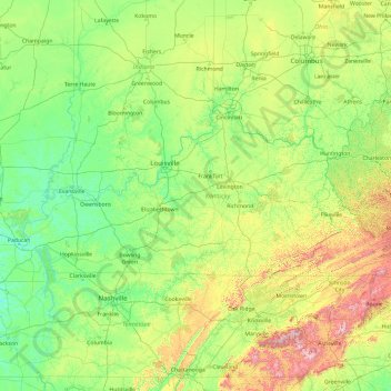
Name: Kentucky topographic map, elevation, terrain.
Location: Kentucky, United States (36.49712 -89.57151 39.14780 -81.96454)
Average elevation: 302 m
Minimum elevation: 92 m
Maximum elevation: 1,919 m
Gear up for your next adventure:
As an Amazon Associate, this site earns from qualifying purchases at no extra cost to you.
Make a donation
Other topographic maps
Click on a map to view its topography, its elevation and its terrain.
Appalachian Mountains
United States > North Carolina > Yancey County
The Appalachian Mountains (French: Appalaches), often called the Appalachians, are a system of mountains in eastern to northeastern North America. The Appalachians first formed roughly 480 million years ago during the Ordovician Period. They once reached elevations similar to those of the Alps and the Rocky…
Average elevation: 1,463 m
Virginia Beach
United States > Virginia > Virginia Beach
According to the United States Census Bureau, the city has a total area of 497 square miles (1,290 km2), of which 249 square miles (640 km2) is land and 248 square miles (640 km2) (49.9%) is water. It is the largest city in Virginia by total area and third-largest city land area. The average elevation is 12…
Average elevation: 2 m
Gear up for your next adventure:
As an Amazon Associate, this site earns from qualifying purchases at no extra cost to you.
Make a donation
Little Saint James Island
United States > United States Virgin Islands > Saint Thomas - Saint John District
Average elevation: 1 m
Mauna Kea
United States > Hawaii > Hawaiʻi County
Mauna Kea (/ˌmaʊnə ˈkeɪə/; Hawaiian: [ˈmɐwnə ˈkɛjə]; abbreviation for Mauna a Wākea) is a dormant volcano on the island of Hawaiʻi. Its peak is 4,207.3 m (13,803 ft) above sea level, making it the highest point in the state of Hawaiʻi and second-highest peak of an island on Earth. The peak is…
Average elevation: 3,978 m
Palm Harbor
United States > Florida > Pinellas County
Palm Harbor is characterized by its unique topography, which features a relatively rare hilly landscape for the region. Unlike much of the surrounding areas in Pinellas County, which are predominantly flat, Palm Harbor includes elevations that can reach up to about 75 feet above sea level. This elevation gives…
Average elevation: 9 m
Columbus
United States > Ohio > Franklin County > Columbus
The confluence of the Scioto and Olentangy rivers is just north-west of Downtown Columbus. Several smaller tributaries course through the Columbus metropolitan area, including Alum Creek, Big Walnut Creek, and Darby Creek. Columbus is considered to have relatively flat topography thanks to a large glacier that…
Average elevation: 255 m
Gear up for your next adventure:
As an Amazon Associate, this site earns from qualifying purchases at no extra cost to you.
Make a donation
Central Park
United States > New York > New York County > New York
In June 1856, Fernando Wood appointed a "consulting board" of seven people, headed by author Washington Irving, to inspire public confidence in the proposed development. Wood hired military engineer Egbert Ludovicus Viele as the park's chief engineer, tasking him with a topographical survey of the site. The…
Average elevation: 26 m
Ponte Vedra Beach
United States > Florida > Saint Johns County > Ponte Vedra Beach
Ponte Vedra Beach is characterized by its gently rolling terrain that is primarily flat and lies only about 15 feet above sea level. The landscape is predominantly shaped by coastal dunes and the proximity to the Atlantic Ocean, resulting in sandy beaches interspersed with vegetation typical of barrier island…
Average elevation: 3 m
San Francisco Bay Area
United States > California > San Francisco
The San Francisco Bay Area is characterized by a diverse and dynamic topography shaped by geological processes over millions of years. This region features a combination of coastal plains, steep hills, and rugged mountains, all influenced by the tectonic activity associated with the nearby San Andreas Fault…
Average elevation: 113 m
Gear up for your next adventure:
As an Amazon Associate, this site earns from qualifying purchases at no extra cost to you.
Make a donation
Tug Hill
United States > New York > Oswego County
The core Tug Hill region encompasses 150,000 acres (610 km2) of unbroken, generally second-growth, northern hardwood forest, and is drained by a vast network of streams. Important rivers and streams whose headwaters are located within the Tug Hill region include the Mohawk River, Deer River, Salmon River, Mad…
Average elevation: 109 m
Gear up for your next adventure:
As an Amazon Associate, this site earns from qualifying purchases at no extra cost to you.
Make a donation
Gear up for your next adventure:
As an Amazon Associate, this site earns from qualifying purchases at no extra cost to you.
Make a donation
San Diego
United States > California > San Diego County > San Diego
The climate in San Diego, like most of Southern California, often varies significantly over short geographical distances, resulting in microclimates. In San Diego, this is mostly because of the city's topography (the Bay, and the numerous hills, mountains, and canyons). Frequently, particularly during the "May…
Average elevation: 57 m
Gear up for your next adventure:
As an Amazon Associate, this site earns from qualifying purchases at no extra cost to you.
Make a donation
Uinta Mountains
The high Uintas were extensively glaciated during the last ice age, and most of the large stream valleys on both the north and south sides of the range held long valley glaciers. However, despite reaching to over 13,500 feet (4,110 m) in elevation, the climate today is sufficiently dry that no glaciers…
Average elevation: 2,363 m
Rocky Mountains
United States > Wyoming > Teton County
Agriculture and forestry are major industries. Agriculture includes dryland and irrigated farming and livestock grazing. Livestock are frequently moved between high-elevation summer pastures and low-elevation winter pastures, a practice known as transhumance.
Average elevation: 2,292 m
Gear up for your next adventure:
As an Amazon Associate, this site earns from qualifying purchases at no extra cost to you.
Make a donation
Anna Maria island
United States > Florida > Manatee County
Anna Maria Island features a flat, sandy topography typical of a barrier island on the Gulf Coast. With an average elevation of around 15 feet above sea level, the terrain includes broad beaches, low dunes, and narrow stretches of sandy soil, making it highly vulnerable to storm surges and tidal flooding. The…
Average elevation: 2 m
Boston
United States > Massachusetts > Suffolk County > Boston
Boston has an area of 89.63 sq mi (232.1 km2)—48.4 sq mi (125.4 km2) (54%) of land and41.2 sq mi (106.7 km2) (46%) of water. The city's official elevation, as measured at Logan International Airport, is 19 ft (5.8 m) above sea level. The highest point in Boston is Bellevue Hill at 330 ft (100 m) above sea…
Average elevation: 26 m
El Dorado Hills
United States > California > El Dorado County > Cameron Park
El Dorado Hills (EDH), as defined by the 2010 census-designated place (CDP), is at the western border of El Dorado County, between the City of Folsom and the unincorporated community of Cameron Park. The northern limits of the CDP are Folsom Lake and the South Fork of the American River, where river rafters…
Average elevation: 254 m
Gear up for your next adventure:
As an Amazon Associate, this site earns from qualifying purchases at no extra cost to you.
Make a donation
Wesley Chapel
United States > Florida > Pasco County
According to the United States Census Bureau, the CDP has a total area of 6.1 square miles (16 km2), of which 6.1 square miles (16 km2) is land and 0.04 square miles (0.10 km2) (0.49%) is water. The elevation is about 100 feet (30 m), combined with an inland location, creates more temperature variation in the…
Average elevation: 19 m
Woxall
United States > Pennsylvania > Montgomery County > Upper Salford Township
Average elevation: 98 m
Crested Butte
United States > Colorado > Gunnison County
Crested Butte is located in north-central Gunnison County on the west side of the valley of the Slate River, along Coal Creek. Colorado State Highway 135 runs south from Crested Butte 27 miles (43 km) to Gunnison, the county seat. According to the United States Census Bureau, the town of Crested Butte has a…
Average elevation: 2,798 m
Gear up for your next adventure:
As an Amazon Associate, this site earns from qualifying purchases at no extra cost to you.
Make a donation
Buckeye Lake
United States > North Carolina > Watauga County > Beech Mountain
Average elevation: 1,160 m
Lake Raleigh
United States > North Carolina > Wake County > Raleigh > Isle Forest
Average elevation: 104 m
Gear up for your next adventure:
As an Amazon Associate, this site earns from qualifying purchases at no extra cost to you.
Make a donation
East Texas
United States > Pennsylvania > Lehigh County > Lower Macungie Township
Average elevation: 126 m
Golden Gate Park
United States > California > San Francisco
In the 1860s, San Franciscans began to feel the need for a spacious public park similar to Central Park, which was then taking shape in New York City. Golden Gate Park was carved out of unpromising sand and shore dunes that were known as the Outside Lands, in an unincorporated area west of San Francisco's…
Average elevation: 71 m
Gear up for your next adventure:
As an Amazon Associate, this site earns from qualifying purchases at no extra cost to you.
Make a donation
Blue Ridge Mountains
United States > Virginia > Botetourt County
Although the term "Blue Ridge" is sometimes applied exclusively to the eastern edge or front range of the Appalachian Mountains, the geological definition of the Blue Ridge province extends westward to the Ridge and Valley area, encompassing the Great Smoky Mountains, the Great Balsams, the Roans, the Blacks,…
Average elevation: 460 m
Blue Ridge Mountains
United States > Virginia > Botetourt County
Although the term "Blue Ridge" is sometimes applied exclusively to the eastern edge or front range of the Appalachian Mountains, the geological definition of the Blue Ridge province extends westward to the Ridge and Valley area, encompassing the Great Smoky Mountains, the Great Balsams, the Roans, the Blacks,…
Average elevation: 461 m
Gear up for your next adventure:
As an Amazon Associate, this site earns from qualifying purchases at no extra cost to you.
Make a donation
Middlebury Center
United States > Pennsylvania > Tioga County > Middlebury Township
Average elevation: 462 m
Gear up for your next adventure:
As an Amazon Associate, this site earns from qualifying purchases at no extra cost to you.
Make a donation
Mount Hood
United States > Oregon > Hood River County
Timberline Lodge is a National Historic Landmark located on the southern flank of Mount Hood just below Palmer Glacier, with an elevation of about 6,000 ft (1,800 m).
Average elevation: 2,716 m
North Chelmsford
United States > Massachusetts > Middlesex County > Chelmsford
Average elevation: 41 m
Hawthorne
United States > New York > Westchester County > Town of Mount Pleasant
Average elevation: 119 m
Altacanyada
United States > California > Los Angeles County > La Cañada Flintridge
Average elevation: 584 m
Gear up for your next adventure:
As an Amazon Associate, this site earns from qualifying purchases at no extra cost to you.
Make a donation
Mauna Loa
United States > Hawaii > Hawaiʻi County
Mauna Loa is the largest subaerial and second largest overall volcano in the world (behind Tamu Massif), covering a land area of 5,271 km2 (2,035 sq mi) and spans a maximum width of 120 km (75 mi). Consisting of approximately 65,000 to 80,000 km3 (15,600 to 19,200 cu mi) of solid rock, it makes up more than…
Average elevation: 4,037 m
Enterprise
United States > California > Shasta County > Redding
It lies at an elevation of 538 feet (164 m).
Average elevation: 166 m
Gear up for your next adventure:
As an Amazon Associate, this site earns from qualifying purchases at no extra cost to you.
Make a donation
Port Charlotte
United States > Florida > Charlotte County
Port Charlotte is characterized by a predominantly flat and low-lying terrain, typical of Florida’s coastal landscape. The area features a network of waterways, including the Peace River and Charlotte Harbor, which provide ample opportunities for recreational activities like boating and fishing. Elevations…
Average elevation: 4 m
The Bluffs Lake Dam
United States > Missouri > Saint Charles County > Harvester
Average elevation: 157 m
Gear up for your next adventure:
As an Amazon Associate, this site earns from qualifying purchases at no extra cost to you.
Make a donation
Little Saint James Island
United States > United States Virgin Islands > Saint Thomas - Saint John District
Average elevation: 1 m
Scottsdale
United States > Arizona > Maricopa County > Scottsdale
The city is in the Salt River Valley, or the "Valley of the Sun," in the northern reaches of the Sonoran Desert. Scottsdale, 31 mi (50 km) long and 11.4 mi (18.3 km) wide at its widest point, shares boundaries with many other municipalities and entities. On the west, Scottsdale is bordered by Phoenix, Paradise…
Average elevation: 414 m
Gear up for your next adventure:
As an Amazon Associate, this site earns from qualifying purchases at no extra cost to you.
Make a donation
Turtle Mountain State Recreational Forest
United States > North Dakota > Bottineau County
Average elevation: 636 m
Gear up for your next adventure:
As an Amazon Associate, this site earns from qualifying purchases at no extra cost to you.
Make a donation
Florida Keys
United States > Florida > Monroe County
Tropical cyclones present special dangers and challenges to the entire Keys. Because no area of the islands is more than 20 feet (6.1 m) above sea level (and many are only a few feet elevation), and water surrounds the islands, nearly every neighborhood is subject to flooding as well as hurricane winds. In…
Average elevation: 0 m
Jensen Beach
United States > Florida > Martin County
The Skyline Drive area includes some of the highest points in the community, reaching an elevation of 70 feet (21 m) at one point.
Average elevation: 5 m
Appalachian Mountains
United States > North Carolina > Yancey County
The Appalachian Mountains (French: Appalaches), often called the Appalachians, are a system of mountains in eastern to northeastern North America. The Appalachians first formed roughly 480 million years ago during the Ordovician Period. They once reached elevations similar to those of the Alps and the Rocky…
Average elevation: 1,463 m
Gear up for your next adventure:
As an Amazon Associate, this site earns from qualifying purchases at no extra cost to you.
Make a donation
Daley Corner
United States > Massachusetts > Bristol County > Easton > North Easton
Average elevation: 47 m
Gear up for your next adventure:
As an Amazon Associate, this site earns from qualifying purchases at no extra cost to you.
Make a donation