Geolocate

Topeka topographic map

Click on the map to display elevation.

About this map

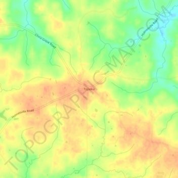
Name: Topeka topographic map, elevation, terrain.

Location: Topeka, Lawrence County, Mississippi, United States (31.39517 -90.20842 31.43517 -90.16842)

Average elevation: 133 m

Minimum elevation: 108 m

Maximum elevation: 148 m

Gear up for your next adventure:

🥾Lightweight Hiking Shoes - Comfortable shoes for day hikes
🪜Heavy Duty Carabiners - Multi-use clips for securing gear to your backpack
🥾Waterproof Trail Shoes - Shoes designed to handle wet terrain
Tent Footprint - Protect tent floor and increase durability
❄️Traction Ice Cleats - Slip-on spikes for icy trails and winter hiking

As an Amazon Associate, this site earns from qualifying purchases at no extra cost to you.