
Make a donation
Gear up for your next adventure:
As an Amazon Associate, this site earns from qualifying purchases at no extra cost to you.
Little Saint James Island topographic map
Click on the map to display elevation.
Make a donation
Gear up for your next adventure:
As an Amazon Associate, this site earns from qualifying purchases at no extra cost to you.
About this map
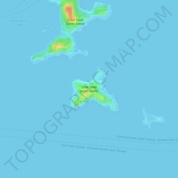
Name: Little Saint James Island topographic map, elevation, terrain.
Average elevation: 1 m
Minimum elevation: 0 m
Maximum elevation: 50 m
Make a donation
Gear up for your next adventure:
As an Amazon Associate, this site earns from qualifying purchases at no extra cost to you.
Other topographic maps
Click on a map to view its topography, its elevation and its terrain.
Saint John
United States > United States Virgin Islands > Saint Thomas - Saint John District > East End
Average elevation: 26 m
Saint Thomas
United States > United States Virgin Islands > Saint Thomas - Saint John District > Charlotte Amalie
Average elevation: 15 m
Little Saint James Island
United States > United States Virgin Islands > Saint Thomas - Saint John District
Average elevation: 1 m
Little Saint James Island
United States > United States Virgin Islands > Saint Thomas - Saint John District
Average elevation: 1 m
Make a donation
Gear up for your next adventure:
As an Amazon Associate, this site earns from qualifying purchases at no extra cost to you.
Saint John
United States > United States Virgin Islands > Saint Thomas - Saint John District > East End
Average elevation: 26 m
Coral Bay
United States > United States Virgin Islands > Saint Thomas - Saint John District
Average elevation: 84 m
Little Saint James Island
United States > United States Virgin Islands > Saint Thomas - Saint John District
Average elevation: 1 m
Peter Peak
United States > United States Virgin Islands > Saint Thomas - Saint John District
Average elevation: 129 m
Make a donation
Gear up for your next adventure:
As an Amazon Associate, this site earns from qualifying purchases at no extra cost to you.
Saint John
United States > United States Virgin Islands > Saint Thomas - Saint John District > East End
Average elevation: 26 m
Saint John
United States > United States Virgin Islands > Saint Thomas - Saint John District > Coral Harbour
Average elevation: 26 m
Charlotte Amalie
United States > United States Virgin Islands > Saint Thomas - Saint John District > Charlotte Amalie
Average elevation: 60 m
Saint Thomas
United States > United States Virgin Islands > Saint Thomas - Saint John District > Charlotte Amalie
Average elevation: 15 m
Make a donation
Gear up for your next adventure:
As an Amazon Associate, this site earns from qualifying purchases at no extra cost to you.
Saint John
United States > United States Virgin Islands > Saint Thomas - Saint John District > East End
Average elevation: 26 m
Cruz Bay
United States > United States Virgin Islands > Saint Thomas - Saint John District
Average elevation: 24 m
Saint John
United States > United States Virgin Islands > Saint Thomas - Saint John District > East End
Average elevation: 26 m
Charlotte Amalie West
United States > United States Virgin Islands > Saint Thomas - Saint John District > Charlotte Amalie
Average elevation: 52 m
Make a donation
Gear up for your next adventure:
As an Amazon Associate, this site earns from qualifying purchases at no extra cost to you.
Saint Thomas
United States > United States Virgin Islands > Saint Thomas - Saint John District > Charlotte Amalie
Average elevation: 15 m
Saint Thomas
United States > United States Virgin Islands > Saint Thomas - Saint John District > Charlotte Amalie
Average elevation: 15 m
Charlotte Amalie West
United States > United States Virgin Islands > Saint Thomas - Saint John District
Average elevation: 40 m
Charlotte Amalie
United States > United States Virgin Islands > Saint Thomas - Saint John District > Charlotte Amalie
Average elevation: 60 m
Make a donation
Gear up for your next adventure:
As an Amazon Associate, this site earns from qualifying purchases at no extra cost to you.
Saint John
United States > United States Virgin Islands > Saint Thomas - Saint John District > East End
Average elevation: 26 m
Central
United States > United States Virgin Islands > Saint Thomas - Saint John District
Average elevation: 174 m
Saint Thomas
United States > United States Virgin Islands > Saint Thomas - Saint John District > Charlotte Amalie
Average elevation: 15 m
Saint Thomas
United States > United States Virgin Islands > Saint Thomas - Saint John District > Charlotte Amalie
Average elevation: 15 m
Make a donation
Gear up for your next adventure:
As an Amazon Associate, this site earns from qualifying purchases at no extra cost to you.
Saint Thomas
United States > United States Virgin Islands > Saint Thomas - Saint John District > Charlotte Amalie
Average elevation: 15 m
Fortuna
United States > United States Virgin Islands > Saint Thomas - Saint John District
Average elevation: 40 m
Charlotte Amalie
United States > United States Virgin Islands > Saint Thomas - Saint John District > Charlotte Amalie
Average elevation: 62 m
Anna's Retreat
United States > United States Virgin Islands > Saint Thomas - Saint John District
Average elevation: 99 m
Make a donation
Gear up for your next adventure:
As an Amazon Associate, this site earns from qualifying purchases at no extra cost to you.
Saint John
United States > United States Virgin Islands > Saint Thomas - Saint John District > East End
Average elevation: 26 m
Charlotte Amalie
United States > United States Virgin Islands > Saint Thomas - Saint John District > Charlotte Amalie
Average elevation: 68 m