
Camiguin topographic map
Interactive map
Click on the map to display elevation.
About this map
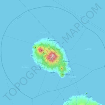
Name: Camiguin topographic map, elevation, terrain.
Location: Camiguin, Northern Mindanao, Philippinen (8.98810 124.49418 9.40003 124.96392)
Average elevation: 34 m
Minimum elevation: -1 m
Maximum elevation: 1,601 m
In einem Observatorium des Philippine Institute of Volcanology and Seismology (PHIVOLCS) werden in 396 Meter Höhe, nahe der Hauptstadt, die Aktivitäten der sieben Inselvulkane Mount Vulcan (letzte Eruption 1871), Mount Guinsiliban, Mount Tres Marias, Mount Uhay, Mount Mambajao (1240 Meter), der mit 1580 Meter von allen höchste Mount Timpoong, vor allem aber der zuletzt aktive, der Mount Hibok-Hibok (1332 Meter)[8] überwacht, dessen Hauptkrater knapp 5 Kilometer entfernt ist. Sein Name ist lautmalend und hängt mit dem Geräusch zusammen, das eine kochende Lava verursacht: hi … bok, hi … bok …. Zu dem Monitoring gehören neben der Registrierung der Daten des seismologischen Netzes, Veränderungen der Gas- und Dampfaustritte, Temperaturänderungen, qualitative und quantitative chemische Analysen von Seen und heißen Quellen.
Other topographic maps
Click on a map to view its topography, its elevation and its terrain.
Samay
Philippinen > Misamis Oriental > Gingoog
Samay, Gingoog, Misamis Oriental, Northern Mindanao, 9014, Philippinen
Average elevation: 310 m
San Augustin
San Augustin, Bohol, Central Visayas, 6331, Philippinen
Average elevation: 224 m
Bato
Philippinen > Basilan > Lamitan
Bato, Lamitan, Basilan, Bangsamoro, 7302, Philippinen
Average elevation: 16 m
San Pedro
San Pedro, Laguna, Calabarzon, 4023, Philippinen
Average elevation: 29 m
Subic
Subic, Zambales, Central Luzon, 2209, Philippinen
Average elevation: 171 m
River Side
Philippinen > Cebu > Poro > Paz
River Side, Paz, Poro, Cebu, Central Visayas, Philippinen
Average elevation: 16 m
Aspang
Philippinen > South Cotabato > General Santos
Aspang, General Santos, South Cotabato, Soccsksargen, Philippinen
Average elevation: 331 m
Mount Apo
Philippinen > Davao del Sur > Bansalan
Mount Apo, Bansalan, Davao del Sur, Davao Region, 8005, Philippinen
Average elevation: 2,416 m
San Carlos
San Carlos, West-Negros, Western Visayas, 6127, Philippinen
Average elevation: 190 m
Itbayat
Philippinen > Batanes > Itbayat
Itbayat, Batanes, Cagayan Valley, 3905, Philippinen
Average elevation: 31 m
Sirao Peak
Sirao Peak, Cebu-Stadt, Central Visayas, Philippinen
Average elevation: 493 m
Basay
Basay, Ost-Negros, Central Visayas, 6222, Philippinen
Average elevation: 71 m
Bal-Marcoville
Bal-Marcoville, Baguio, Cordillera Administrative Region, 2600, Philippinen
Average elevation: 1,432 m
Banahaw
Banahaw, 2nd District, Marinduque, Mimaropa, 4902, Philippinen
Average elevation: 110 m
Ungka II
Philippinen > Iloilo > Pavia
Ungka II, Pavia, Iloilo, Western Visayas, 5001, Philippinen
Average elevation: 13 m
Pio Cruzcosa
Philippinen > Bulacan > Calumpit
Pio Cruzcosa, Calumpit, Bulacan, Central Luzon, 3000, Philippinen
Average elevation: 4 m
Caratao
Philippinen > Oriental Mindoro > Bulalacao
Caratao, Bulalacao, Oriental Mindoro, Mimaropa, Philippinen
Average elevation: 30 m
Baguio
Baguio, Cordillera Administrative Region, 2600, Philippinen
Average elevation: 1,371 m
Surigao
Philippinen > Surigao Del Norte
Surigao, Surigao del Norte, Caraga, 8400, Philippinen
Average elevation: 40 m
Murcia
Murcia, West-Negros, Western Visayas, 6129, Philippinen
Average elevation: 277 m
Callao
Callao, Isabela, Cagayan Valley, 3306, Philippinen
Average elevation: 74 m
Marawi
Marawi, Lanao del Sur, Bangsamoro, 9700, Philippinen
Average elevation: 707 m
File
Philippinen > Surigao Del Norte > Mat-i
File, Mat-i, Surigao del Norte, Caraga, Philippinen
Average elevation: 105 m
Burgos
Philippinen > Tarlac > Paniqui
Burgos, Paniqui, Tarlac, Central Luzon, Philippinen
Average elevation: 29 m