
Santa Fe topographic map
Interactive map
Click on the map to display elevation.
About this map
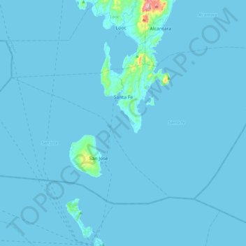
Name: Santa Fe topographic map, elevation, terrain.
Location: Santa Fe, Romblon, Mimaropa, Philippinen (11.99831 121.82069 12.23085 122.20474)
Average elevation: 7 m
Minimum elevation: 0 m
Maximum elevation: 430 m
Other topographic maps
Click on a map to view its topography, its elevation and its terrain.
Tablas Island
Tablas Island, Looc, Romblon, Mimaropa, Philippinen
Average elevation: 26 m