
Fort Augustus topographic map
Interactive map
Click on the map to display elevation.
About this map
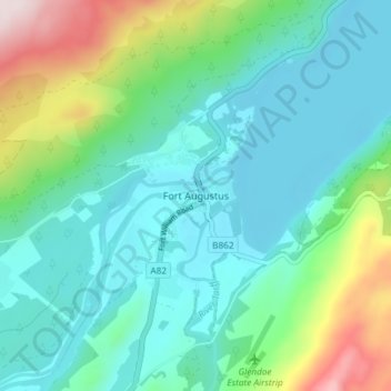
Name: Fort Augustus topographic map, elevation, terrain.
Location: Fort Augustus, Highland, Scotland, PH32 4WA, United Kingdom (57.12433 -4.70149 57.16433 -4.66149)
Average elevation: 115 m
Minimum elevation: 11 m
Maximum elevation: 456 m
As with most of the British Isles and Scotland, Fort Augustus has an oceanic climate (Köppen: Cfb) with cool summers and mild winters. Like a lot of the surrounding area, sunshine levels are low at around 1,000 hours per annum and temperatures are unpredictable – Fort Augustus holds the UK's joint lowest May temperature record of −9.4 °C (15.1 °F). This is the latest point in the run up to summer that such a low temperature has been recorded, suggesting it can become a frost trap on calm clear nights due to its valley location. That same low lying topography can also give rise to some high temperatures on occasion – Fort Augustus held the UK daily high temperature record for 16 December for almost 80 years.
Other topographic maps
Click on a map to view its topography, its elevation and its terrain.
Culloden
United Kingdom > Scotland > Highland
Culloden, Highland, Scotland, United Kingdom
Average elevation: 51 m
Morar
United Kingdom > Scotland > Highland
Morar, Highland, Scotland, PH40 4PH, United Kingdom
Average elevation: 30 m
Wick
United Kingdom > Scotland > Highland
Wick, Highland, Scotland, KW1 4NB, United Kingdom
Average elevation: 20 m
Loch Ness
United Kingdom > Scotland > Highland > Dores
Loch Ness, Dores, Highland, Scotland, PH32 4BN, United Kingdom
Average elevation: 340 m
Camore
United Kingdom > Scotland > Highland > Evelix
Camore, Evelix, Highland, Scotland, IV25 3HX, United Kingdom
Average elevation: 31 m
Salen
United Kingdom > Scotland > Highland > Salen
Salen, Highland, Scotland, PH36 4JN, United Kingdom
Average elevation: 83 m
Kiltarlity
United Kingdom > Scotland > Highland > Kiltarlity
Kiltarlity, Highland, Scotland, IV4 7HQ, United Kingdom
Average elevation: 66 m
Fassfern
United Kingdom > Scotland > Highland > Fassfern
Fassfern, Highland, Scotland, PH33 7NP, United Kingdom
Average elevation: 84 m
Nairn
United Kingdom > Scotland > Highland
Nairn, Highland, Scotland, IV12 4BW, United Kingdom
Average elevation: 18 m
Kilbride
United Kingdom > Scotland > Highland
Kilbride, Highland, Scotland, IV49 9AT, United Kingdom
Average elevation: 116 m
Dunvegan
United Kingdom > Scotland > Highland > Dunvegan
Dunvegan, Highland, Scotland, IV55 8WB, United Kingdom
Average elevation: 41 m
Dingwall
United Kingdom > Scotland > Highland > Dingwall
Dingwall, Highland, Scotland, IV15 9RU, United Kingdom
Average elevation: 94 m
Ben Nevis
United Kingdom > Scotland > Highland
Ben Nevis, Highland, Scotland, United Kingdom
Average elevation: 912 m
Inverasdale
United Kingdom > Scotland > Highland
Inverasdale, Highland, Scotland, IV22 2LP, United Kingdom
Average elevation: 47 m
Scottish Highlands
United Kingdom > Scotland > Highland
Scottish Highlands, Highland, Scotland, United Kingdom
Average elevation: 907 m