
Chitwan topographic map
Click on the map to display elevation.
Chitwan
Chitwan is known for Taas (Nepali: तास), a spicy fried goat meat dish served with bhuja or cheura. Momo, Bhuteko Bhat (fried rice), and sukuti are other popular dishes. Dal bhat (steamed rice and lentils), is the staple food of the area, though meat and dairy products are also consumed. Other popular cuisines include Newari and Tharu and Thakali. For centuries, traditional fermented foods and beverages have constituted about 20% of the local diet. Depending on altitude, finger millet, wheat, buckwheat, barley, vegetable, rice, potato, soybeans, etc. are grown.
About this map
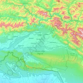
Name: Chitwan topographic map, elevation, terrain.
Location: Chitwan, Bagamati Province, Nepal (27.35613 83.91936 27.88088 84.79637)
Average elevation: 469 m
Minimum elevation: 93 m
Maximum elevation: 2,084 m
Other topographic maps
Click on a map to view its topography, its elevation and its terrain.
Lalitpur
Nepal > Bagamati Province > Lalitpur
Lalitpur (Nepali: ललितपुर [ləˈlɪt̪pʊɾ]), locally known as Yala (Nepal Bhasa: 𑐫𑐮 [jəˈlʌ]) is a metropolitan city and fourth most populous city of Nepal with 299,843 inhabitants living in 77,159 households per the 2021 census. It is located in the south-central part of…
Average elevation: 1,608 m
Sarketari Baandh/ Risk And Hazards/ Flood
Nepal > Bagamati Province > Dhading > Nilakantha
Average elevation: 934 m
Bhimeshwar
Nepal > Bagamati Province > Dolakha
Bhimeshwar, (formerly Charikot), is a municipality in north-eastern Nepal and the headquarters of Dolakha District in Bagmati Province that was established in 1997 by merging the former village development committees Charikot, Dolakha Town, Makaibari, Mati, Suspaa, and Lankuri Danda. At the time of the 2011…
Average elevation: 1,583 m
Mulpani Pipalbot
Nepal > Bagamati Province > Kathmandu > Kageshwori Manohara
Average elevation: 1,336 m
Melamchi
Nepal > Bagamati Province > Sindhupalchowk
The lower part of Melamchi valley has a sub-tropical climate, while the upper part has a cool temperate climate. The upper part of the valley receives more rainfall than in the lower part. Heavy rainfall occurs in June, July and August. Rainfall in January and February is the lowest. The annual average…
Average elevation: 1,216 m
Nagarkot
Nepal > Bagamati Province > Kavrepalanchok
At the time of the 2021 census it had a population of 5,234 and had 1,084 houses in it. At an elevation of 2,195 meters, it is considered one of the most scenic spots in Bhaktapur District. Nagarkot also offers views of the Kathmandu Valley. The scenery of the place makes it a popular hiking route for…
Average elevation: 1,679 m
Nagarkot
Nepal > Bagamati Province > Kavrepalanchok
Nagarkot (Nepali: नगरकोट) is a former village development committee located 32 km east of Kathmandu, Nepal, in Bhaktapur District in Bagmati Province and as of 2015 part of Nagarkot Municipality. At the time of the 2011 census it had a population of 4,571 and had 973 houses in it. At an elevation…
Average elevation: 1,679 m
Lalitpur
Nepal > Bagamati Province > Lalitpur
Lalitpur Metropolitan City (Sanskrit: पाटन Pāṭana, Nepal bhasa : 𑐫𑐮 Yala) is a metropolitan city and fourth most populous city of Nepal with 299,843 inhabitants living in 49,044 households per the 2021 census. It is located in the south-central part of Kathmandu Valley, a large valley in…
Average elevation: 1,608 m
Dhading Besi
Nepal > Bagamati Province > Dhading
It is at 27°54'45.9"N 84°53'46.2"E at an altitude of 612 metres.
Average elevation: 873 m
Panorama of Banepa Valley & Himalaya Mountains
Nepal > Bagamati Province > Kavrepalanchok > Banepa
Average elevation: 1,611 m
Lalitpur
Nepal > Bagamati Province > Lalitpur
Lalitpur Metropolitan City (Sanskrit: पाटन Pāṭana, Nepal bhasa : 𑐫𑐮 Yela, ) is a Metropolitan city and fourth most populous city of Nepal with 299,843 inhabitants living in 49,044 households per 2021 census. It is located in the south-central part of Kathmandu Valley, a large valley in the…
Average elevation: 1,608 m
Lalitpur
Nepal > Bagamati Province > Lalitpur
Lalitpur (Nepali: ललितपुर) is a metropolitan city and fourth most populous city of Nepal with 299,843 inhabitants living in 77,159 households per the 2021 census. It is located in the south-central part of Kathmandu Valley, a large valley in the high plateaus in central Nepal, at an altitude of…
Average elevation: 1,608 m
Meghauli
Nepal > Bagamati Province > Chitwan
Meghauli Airport, (IATA: MEY, ICAO: VNMG) is located in about 26 km west of the city center of Bharatpur in the Chitwan District. The airport resides at an elevation of 600 feet (183 m) above mean sea level. It has one runway which is 1,085 metres (3,560 ft) in length. It is the gateway airport to Chitwan…
Average elevation: 156 m
Nagarkot
Nepal > Bagamati Province > Kavrepalanchok
At the time of the 2021 census it had a population of 5,234 and had 1,084 houses in it. At an elevation of 2,195 meters, it is considered one of the most scenic spots in Bhaktapur District. Nagarkot also offers views of the Kathmandu Valley. The scenery of the place makes it a popular hiking route for…
Average elevation: 1,679 m
Lalitpur
Nepal > Bagamati Province > Lalitpur
Lalitpur (Nepali: ललितपुर) is a metropolitan city and fourth most populous city of Nepal with 299,843 inhabitants living in 77,159 households per the 2021 census. It is located in the south-central part of Kathmandu Valley, a large valley in the high plateaus in central Nepal, at an altitude of…
Average elevation: 1,608 m
Tsho Rolpa Lake
Nepal > Bagamati Province > Dolakha
Tsho Rolpa (also Cho Rolpa) is one of the biggest glacial lakes in Nepal. The lake, which is located at an altitude of 4,580 metres (15,030 ft) in the Rolwaling Valley, Dolakha District, has grown considerably over the last 50 years due to glacial melting in the Himalayas.
Average elevation: 4,897 m
Lalitpur
Nepal > Bagamati Province > Lalitpur
Lalitpur Metropolitan City (Nepali: ललितपुर महानगरपालिका, Lālitapura Mahānagarapālikā), also known as Patan (Sanskrit: पाटन, Pāṭana), Yala (Newar: 𑐫𑐮), and Manigal, is a metropolitan city and fourth most populous city of Nepal with 299,843 inhabitants…
Average elevation: 1,608 m