Geolocate

Deurali topographic map

Click on the map to display elevation.

About this map

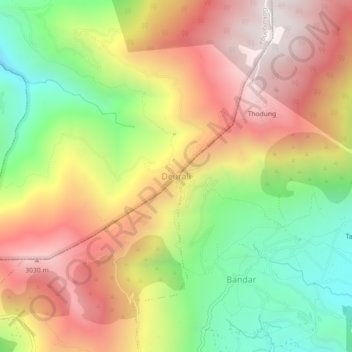
Name: Deurali topographic map, elevation, terrain.

Location: Deurali, Gokulganga, Ramechhap, Bagamati Province, Nepal (27.56253 86.31065 27.60253 86.35065)

Average elevation: 2,580 m

Minimum elevation: 2,007 m

Maximum elevation: 3,132 m

Other topographic maps

Click on a map to view its topography, its elevation and its terrain.

Umakunda

Nepal > Bagamati Province > Ramechhap

Average elevation: 3,322 m

Manthali

Nepal > Bagamati Province > Ramechhap

Average elevation: 1,105 m

Sunapati

Nepal > Bagamati Province > Ramechhap

Average elevation: 1,419 m

Gear up for your next adventure:

🧦Hiking Liner Socks - Thin base layer to prevent friction and blisters
🛶Kayak Accessories - Essential gear for safe and fun kayaking adventures
🔋Emergency Crank Radio - Weather alerts and power without needing batteries
🦟Insect Repellent - Keep mosquitoes and black flies away in wooded areas
🧰Survival Kit - Essential gear for emergencies in the wilderness

As an Amazon Associate, this site earns from qualifying purchases at no extra cost to you.