Geolocate

Paunauti topographic map

Click on the map to display elevation.

About this map

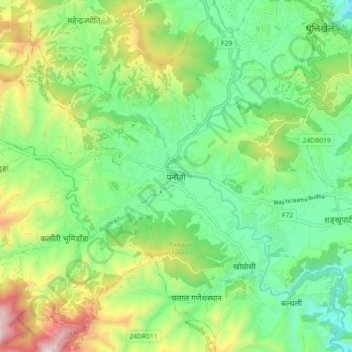
Name: Paunauti topographic map, elevation, terrain.

Location: Paunauti, Kavrepalanchok, Bagamati Province, 45209, Nepal (27.54505 85.47602 27.62505 85.55602)

Average elevation: 1,578 m

Minimum elevation: 1,253 m

Maximum elevation: 2,232 m

Other topographic maps

Click on a map to view its topography, its elevation and its terrain.

Namobuddha

Nepal > Bagamati Province > Kavrepalanchok

Average elevation: 1,284 m

Namobuddha

Nepal > Bagamati Province > Kavrepalanchok

Average elevation: 1,284 m

Mandandeupur

Nepal > Bagamati Province > Kavrepalanchok

Average elevation: 1,149 m

Mandandeupur

Nepal > Bagamati Province > Kavrepalanchok

Average elevation: 1,149 m

Punyamata River

Nepal > Bagamati Province > Kavrepalanchok > Banepa

Average elevation: 1,536 m

Dhulikhel

Nepal > Bagamati Province > Kavrepalanchok

Average elevation: 1,369 m

Dhulikhel

Nepal > Bagamati Province > Kavrepalanchok

Average elevation: 1,369 m

Namobuddha

Nepal > Bagamati Province > Kavrepalanchok

Average elevation: 1,284 m

Gear up for your next adventure:

🧣Merino Neck Gaiter - Protects against wind, sun, and cold at high altitudes
🧊Portable Cooler - Keep food and drinks cold during outdoor adventures
🥾All-Terrain Hiking Boots - Versatile boots for varied hiking conditions
🦟Insect Repellent - Keep mosquitoes and black flies away in wooded areas
🔦LED Flashlight - Powerful and long-lasting flashlight for camping and emergencies

As an Amazon Associate, this site earns from qualifying purchases at no extra cost to you.