Geolocate

Panchkhal topographic map

Click on the map to display elevation.

About this map

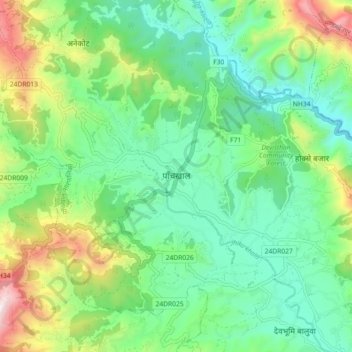
Name: Panchkhal topographic map, elevation, terrain.

Location: Panchkhal, Kavrepalanchok, Bagamati Province, 45212, Nepal (27.60681 85.57986 27.68681 85.65986)

Average elevation: 978 m

Minimum elevation: 713 m

Maximum elevation: 1,597 m

Other topographic maps

Click on a map to view its topography, its elevation and its terrain.

Namobuddha

Nepal > Bagamati Province > Kavrepalanchok

Average elevation: 1,284 m

Namobuddha

Nepal > Bagamati Province > Kavrepalanchok

Average elevation: 1,284 m

Mandandeupur

Nepal > Bagamati Province > Kavrepalanchok

Average elevation: 1,149 m

Mandandeupur

Nepal > Bagamati Province > Kavrepalanchok

Average elevation: 1,149 m

Punyamata River

Nepal > Bagamati Province > Kavrepalanchok > Banepa

Average elevation: 1,536 m

Dhulikhel

Nepal > Bagamati Province > Kavrepalanchok

Average elevation: 1,369 m

Dhulikhel

Nepal > Bagamati Province > Kavrepalanchok

Average elevation: 1,369 m

Namobuddha

Nepal > Bagamati Province > Kavrepalanchok

Average elevation: 1,284 m

Gear up for your next adventure:

🧢Outdoor Visor - Breathable visor for sunny hikes
🔪Outdoor Multitool - Versatile tool for repairs and food prep in the wild
🥾Mountain Trail Shoes - High-traction shoes for mountain trails
🏃Hydration Running Vest - Carry water and maps close to your body for speed
🥾Approach Shoes - Shoes designed for climbing approaches and rugged trails

As an Amazon Associate, this site earns from qualifying purchases at no extra cost to you.