
Make a donation
Gear up for your next adventure:
As an Amazon Associate, this site earns from qualifying purchases at no extra cost to you.
Nagarkot topographic map
Click on the map to display elevation.
Make a donation
Gear up for your next adventure:
As an Amazon Associate, this site earns from qualifying purchases at no extra cost to you.
Nagarkot
At the time of the 2021 census it had a population of 5,234 and had 1,084 houses in it. At an elevation of 2,195 meters, it is considered one of the most scenic spots in Bhaktapur District. Nagarkot also offers views of the Kathmandu Valley. The scenery of the place makes it a popular hiking route for tourists. It is located approximately 7000 ft (2000 m) above sea level and 28 km from Kathmandu International Airport.
Make a donation
Gear up for your next adventure:
As an Amazon Associate, this site earns from qualifying purchases at no extra cost to you.
About this map
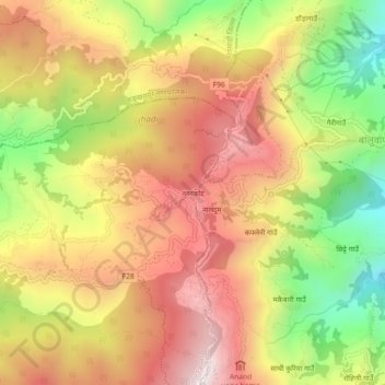
Name: Nagarkot topographic map, elevation, terrain.
Average elevation: 1,679 m
Minimum elevation: 1,214 m
Maximum elevation: 2,059 m
Make a donation
Gear up for your next adventure:
As an Amazon Associate, this site earns from qualifying purchases at no extra cost to you.
Other topographic maps
Click on a map to view its topography, its elevation and its terrain.
Make a donation
Gear up for your next adventure:
As an Amazon Associate, this site earns from qualifying purchases at no extra cost to you.
Make a donation
Gear up for your next adventure:
As an Amazon Associate, this site earns from qualifying purchases at no extra cost to you.