Geolocate

Hetauda topographic map

Click on the map to display elevation.

About this map

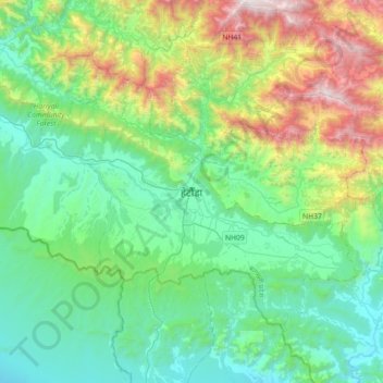
Name: Hetauda topographic map, elevation, terrain.

Location: Hetauda, Makwanpur, Bagamati Province, 44107, Nepal (27.26959 84.87266 27.58959 85.19266)

Average elevation: 789 m

Minimum elevation: 227 m

Maximum elevation: 2,490 m

Other topographic maps

Click on a map to view its topography, its elevation and its terrain.

Kailash

Nepal > Bagamati Province > Makwanpur

Average elevation: 1,270 m

Raksirang-09

Nepal > Bagamati Province > Makwanpur

Average elevation: 1,290 m

Thaha

Nepal > Bagamati Province > Makwanpur

Average elevation: 1,606 m

Gear up for your next adventure:

🥾Light Hiking Boots - Lightweight and comfortable boots for day hikes
🎒Backpack Rain Cover - External shield to keep your entire pack dry
🪑Insulated Seat Pad - Protect your seat from cold rocks and wet logs
🧦Hiking Liner Socks - Thin base layer to prevent friction and blisters
🧥Thermal Fleece Jacket - Versatile insulation for changing mountain temperatures

As an Amazon Associate, this site earns from qualifying purchases at no extra cost to you.