
Murray County topographic map
Interactive map
Click on the map to display elevation.
About this map
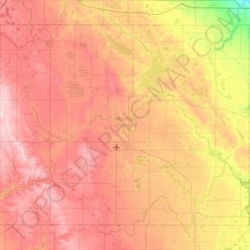
Name: Murray County topographic map, elevation, terrain.
Location: Murray County, Minnesota, United States (43.84900 -96.06532 44.19658 -95.46220)
Average elevation: 485 m
Minimum elevation: 357 m
Maximum elevation: 583 m
The county terrain consists of low rolling hills, dotted with lakes and ponds, with all available area devoted to agriculture. The terrain slopes to the south and east. However, its highest elevation occurs on Buffalo Ridge, a promontory extending about two miles along the crest of the Coteau des Prairies in central Chanarambie Township. The bluff rises a few hundred feet above the adjacent valleys. The county has a total area of 720 square miles (1,900 km2), of which 705 square miles (1,830 km2) is land and 15 square miles (39 km2) (2.1%) is water.
Other topographic maps
Click on a map to view its topography, its elevation and its terrain.
Boy Lake
United States > Minnesota > Itasca County
Boy Lake, Itasca County, Minnesota, United States
Average elevation: 422 m
Frontenac
United States > Minnesota > Goodhue County
Frontenac, Florence Township, Goodhue County, Minnesota, 55026, United States
Average elevation: 243 m
Border
United States > Minnesota > Koochiching County
Border, Koochiching County, Minnesota, United States
Average elevation: 333 m
Lakeville
United States > Minnesota > Dakota County
Lakeville, Dakota County, Minnesota, 55044, United States
Average elevation: 305 m
Edina
United States > Minnesota > Hennepin County
Edina, Hennepin County, Minnesota, United States
Average elevation: 271 m
Eagle Mountain
United States > Minnesota > Cook County
Eagle Mountain, West Cook, Cook County, Minnesota, United States
Average elevation: 596 m
Cyrus
United States > Minnesota > Pope County
Cyrus, Pope County, Minnesota, United States
Average elevation: 348 m
Plymouth
United States > Minnesota > Hennepin County
Plymouth, Hennepin County, Minnesota, United States
Average elevation: 294 m
Coffee Creek
United States > Minnesota > Lake County
Coffee Creek, Lake No. 1, Lake County, Minnesota, United States
Average elevation: 521 m
Ernest Lake
United States > Minnesota > Cook County
Ernest Lake, West Cook, Cook County, Minnesota, United States
Average elevation: 505 m
Apple Valley
United States > Minnesota > Dakota County
Apple Valley, Dakota County, Minnesota, 55124, United States
Average elevation: 301 m
Sandstone
United States > Minnesota > Pine County
Sandstone, Pine County, Minnesota, United States
Average elevation: 332 m
St. James
United States > Minnesota > Watonwan County
St. James, Watonwan County, Minnesota, 56081, United States
Average elevation: 328 m
Carey Creek
United States > Minnesota > Olmsted County
Carey Creek, Olmsted County, Minnesota, 55976, United States
Average elevation: 375 m
Alice Lake
United States > Minnesota > Lake County
Alice Lake, Fall Lake Township, Lake County, Minnesota, United States
Average elevation: 474 m
Elk River
United States > Minnesota > Sherburne County
Elk River, Sherburne County, Minnesota, 55330, United States
Average elevation: 283 m
Sea Gull Lake
United States > Minnesota > Cook County
Sea Gull Lake, West Cook, Cook County, Minnesota, United States
Average elevation: 460 m
Courtland
United States > Minnesota > Nicollet County
Courtland, Nicollet County, Minnesota, 56021, United States
Average elevation: 281 m
Edna Lake
United States > Minnesota > Aitkin County
Edna Lake, Aitkin County, Minnesota, United States
Average elevation: 411 m
Barnes Lake
United States > Minnesota > Carver County > Norwood Young America
Barnes Lake, Norwood Young America, Young America Township, Carver County, Minnesota, United States
Average elevation: 300 m
Lake Itasca
United States > Minnesota > Clearwater County
Lake Itasca, Clearwater County, Minnesota, United States
Average elevation: 463 m
Link Lake
United States > Minnesota > Lake County
Link Lake, Lake County, Minnesota, United States
Average elevation: 452 m
Howard Lake
United States > Minnesota > Wright County
Howard Lake, Wright County, Minnesota, 55349, United States
Average elevation: 312 m
Babbitt
United States > Minnesota > Saint Louis County
Babbitt, Saint Louis County, Minnesota, United States
Average elevation: 484 m
McGrath
United States > Minnesota > Aitkin County
McGrath, Aitkin County, Minnesota, United States
Average elevation: 379 m
Bloomington
United States > Minnesota > Hennepin County
Bloomington, Hennepin County, Minnesota, United States
Average elevation: 255 m
Ash Lake
United States > Minnesota > Saint Louis County
Ash Lake, Saint Louis County, Minnesota, United States
Average elevation: 413 m
Lakefield
United States > Minnesota > Jackson County
Lakefield, Jackson County, Minnesota, United States
Average elevation: 450 m
East Gull Lake
United States > Minnesota > Cass County
East Gull Lake, Cass County, Minnesota, United States
Average elevation: 370 m
Finlayson
United States > Minnesota > Pine County
Finlayson, Pine County, Minnesota, United States
Average elevation: 339 m
North Shore Mining/Lake Superior Overlook
United States > Minnesota > Lake County > Silver Bay
North Shore Mining/Lake Superior Overlook, City Shop Road, Silver Bay, Lake County, Minnesota, 55614, United States
Average elevation: 252 m
Lake Elmo
United States > Minnesota > Washington County
Lake Elmo, Washington County, Minnesota, 55042, United States
Average elevation: 287 m
Beauty Lake
United States > Minnesota > Kanabec County
Beauty Lake, Kanabec County, Minnesota, United States
Average elevation: 347 m
Grand Rapids
United States > Minnesota > Itasca County
Grand Rapids, Itasca County, Minnesota, 55744, United States
Average elevation: 398 m
Fosston
United States > Minnesota > Polk County
Fosston, Polk County, Minnesota, 56542, United States
Average elevation: 393 m
Lanesboro
United States > Minnesota > Fillmore County
Lanesboro, Fillmore County, Minnesota, 55949, United States
Average elevation: 299 m
Byron
United States > Minnesota > Olmsted County
Byron, Olmsted County, Minnesota, 55920, United States
Average elevation: 365 m
Wren Lake
United States > Minnesota > Cass County
Wren Lake, Cass County, Minnesota, United States
Average elevation: 418 m
Shorewood
United States > Minnesota > Hennepin County
Shorewood, Hennepin County, Minnesota, United States
Average elevation: 289 m
Faribault County
Faribault County, Minnesota, United States
Average elevation: 340 m
Gooseberry Lake
United States > Minnesota > Cass County
Gooseberry Lake, Cass County, Minnesota, United States
Average elevation: 418 m
Rainy River
United States > Minnesota > Koochiching County
Rainy River, Koochiching County, Minnesota, 56629, United States
Average elevation: 341 m
Marshall Lake
United States > Minnesota > Cook County
Marshall Lake, West Cook, Cook County, Minnesota, United States
Average elevation: 556 m
Cream Lake
United States > Minnesota > Cook County
Cream Lake, West Cook, Cook County, Minnesota, United States
Average elevation: 574 m
Duck Lake
United States > Minnesota > Crow Wing County > Crosslake
Duck Lake, Crosslake, Crow Wing County, Minnesota, United States
Average elevation: 377 m
George Lake
United States > Minnesota > Cook County
George Lake, West Cook, Cook County, Minnesota, United States
Average elevation: 551 m
Little Swan
United States > Minnesota > Saint Louis County > Hibbing
Little Swan, Hibbing, Saint Louis County, Minnesota, United States
Average elevation: 395 m
Zumbrota
United States > Minnesota > Goodhue County
Zumbrota, Goodhue County, Minnesota, 55992, United States
Average elevation: 312 m