
Felin-Fach topographic map
Click on the map to display elevation.
About this map
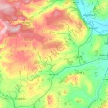
Name: Felin-Fach topographic map, elevation, terrain.
Location: Felin-Fach, Powys, Wales, United Kingdom (51.95871 -3.37587 52.05924 -3.25878)
Average elevation: 244 m
Minimum elevation: 86 m
Maximum elevation: 450 m
Other topographic maps
Click on a map to view its topography, its elevation and its terrain.
Aber Rhaeadr
United Kingdom > Wales > Powys > Llanrhaeadr-ym-Mochnant > Aber Rhaeadr
Average elevation: 193 m
Welshpool
United Kingdom > Wales > Powys
The Mermaid Inn, 28 High Street, was very probably an early 16th-century merchant's house, placed on a burgage plot between the High Street and Alfred Jones Court. The timber-framed building has long storehouse or wing to the rear. The frontage was remodelled c. 1890, by Frank H. Shayler, architect, of…
Average elevation: 156 m
Craig Cerrig Gleisiad a Fan Frynych National Nature Reserve
United Kingdom > Wales > Powys
Average elevation: 473 m