Geolocate

Crossway topographic map

Click on the map to display elevation.

About this map

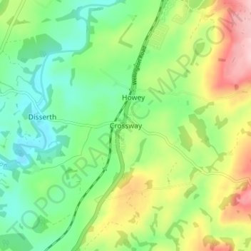
Name: Crossway topographic map, elevation, terrain.

Location: Crossway, Powys, Wales, LD1 5RD, United Kingdom (52.19408 -3.41168 52.23408 -3.37168)

Average elevation: 221 m

Minimum elevation: 152 m

Maximum elevation: 341 m

Gear up for your next adventure:

🥾Approach Boots - Comfortable boots for hiking and climbing approaches
🥾Durable Hiking Shoes - Long-lasting shoes for frequent hiking
🪜Heavy Duty Carabiners - Multi-use clips for securing gear to your backpack
Camping Essentials - All-in-one gear for a comfortable camping trip
🥾Trail Hiking Boots - Supportive boots for rough trails

As an Amazon Associate, this site earns from qualifying purchases at no extra cost to you.