Geolocate

Llanddew topographic map

Click on the map to display elevation.

About this map

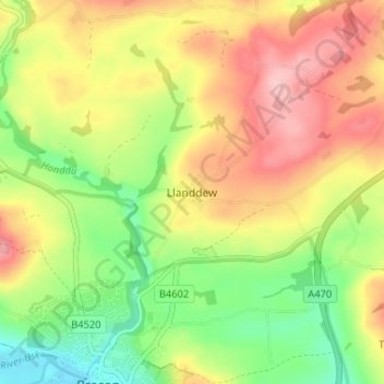
Name: Llanddew topographic map, elevation, terrain.

Location: Llanddew, Powys, Wales, LD3 9SS, United Kingdom (51.94734 -3.39583 51.98734 -3.35583)

Average elevation: 209 m

Minimum elevation: 131 m

Maximum elevation: 291 m

Gear up for your next adventure:

🔦LED Flashlight - Powerful and long-lasting flashlight for camping and emergencies
💡Portable Camping Lamp - Rechargeable lamp for campsite lighting
🥾Light Trekking Boots - Supportive boots for multi-day treks
🛶Kayak Dry Bag - Waterproof storage for kayaking adventures
Lightweight Backpacking Tent - Compact tent for efficient hiking trips

As an Amazon Associate, this site earns from qualifying purchases at no extra cost to you.