Geolocate

Fiuminata topographic map

Click on the map to display elevation.

About this map

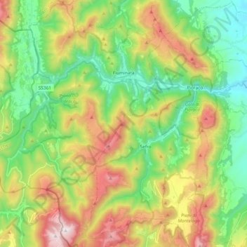
Name: Fiuminata topographic map, elevation, terrain.

Location: Fiuminata, Macerata, Marche, Italy (43.09236 12.82965 43.22715 12.96434)

Average elevation: 792 m

Minimum elevation: 330 m

Maximum elevation: 1,567 m

Other topographic maps

Click on a map to view its topography, its elevation and its terrain.

Appennino

Italy > Marche > Macerata > Pieve Torina

Average elevation: 868 m

Castiglione

Italy > Marche > Macerata > Caldarola

Average elevation: 521 m

Podalla

Italy > Marche > Macerata > Fiastra > Podalla

Average elevation: 898 m

Pitino

Italy > Marche > Macerata > San Severino Marche

Average elevation: 351 m

Collina

Italy > Marche > Macerata > Castelraimondo > Collina

Average elevation: 411 m

Pozzuolo

Italy > Marche > Macerata > Camerino > Pozzuolo

Average elevation: 656 m

Le Grazie

Italy > Marche > Macerata > Tolentino > Le Grazie

Average elevation: 286 m

Aneto

Italy > Marche > Macerata > Montelupone > Aneto

Average elevation: 82 m

Teggiole

Italy > Marche > Macerata > Camerino > Teggiole

Average elevation: 688 m

Vestignano

Italy > Marche > Macerata > Caldarola > Vestignano

Average elevation: 630 m

Gear up for your next adventure:

👖Convertible Hiking Pants - Zip-off legs to adapt to changing weather conditions
🐕Hiking Dog Pack - Let your canine companion carry their own water and food
🥾Lightweight Hiking Shoes - Comfortable shoes for day hikes
🧥Waterproof Pants - Keep dry during rainy hiking conditions
🕯️Camping Lantern - Illuminates your entire campsite with high-efficiency LEDs

As an Amazon Associate, this site earns from qualifying purchases at no extra cost to you.