Geolocate

Collina topographic map

Click on the map to display elevation.

About this map

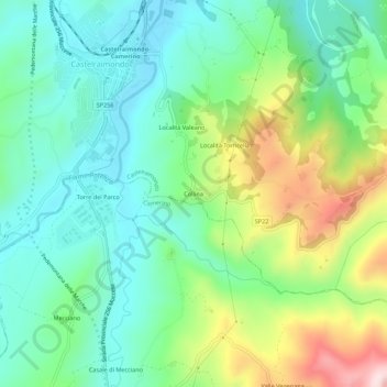
Name: Collina topographic map, elevation, terrain.

Location: Collina, Castelraimondo, Macerata, Marche, Italy (43.17471 13.04693 43.21471 13.08693)

Average elevation: 411 m

Minimum elevation: 284 m

Maximum elevation: 697 m

Gear up for your next adventure:

🔦LED Flashlight - Powerful and long-lasting flashlight for camping and emergencies
🥾Trekking Poles - Adjustable trekking poles to reduce knee stress and improve stability
🔥Camping Stove - Portable stoves to cook outdoors with ease
🦯Trekking Poles - Reduced impact on joints for steep topographic climbs
🚲Bike Repair Kit - Essential tools for on-trail mechanical issues

As an Amazon Associate, this site earns from qualifying purchases at no extra cost to you.