Geolocate

Aneto topographic map

Click on the map to display elevation.

About this map

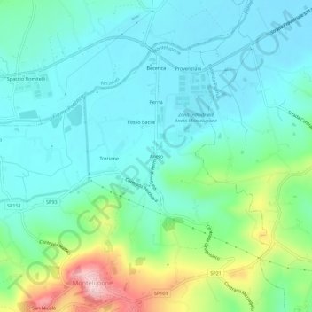
Name: Aneto topographic map, elevation, terrain.

Location: Aneto, Montelupone, Macerata, Marche, Italy (43.34037 13.55887 43.38037 13.59887)

Average elevation: 82 m

Minimum elevation: 21 m

Maximum elevation: 280 m

Gear up for your next adventure:

🥾Hiking Gaiters - Protect legs and shoes from mud, snow, and debris
🕶️Polarized Sunglasses - Protect your eyes with durable polarized lenses
Lightweight Camping Tent - Portable shelter optimized for Canadian backcountry camping
🧴Waterproofing Spray - Restore the DWR coating on jackets and tents
🎒Backpack Rain Cover - External shield to keep your entire pack dry

As an Amazon Associate, this site earns from qualifying purchases at no extra cost to you.