Geolocate

Prižba topographic map

Click on the map to display elevation.

About this map

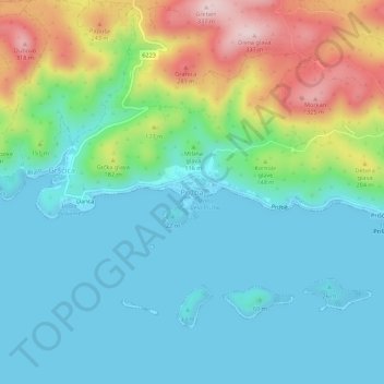
Name: Prižba topographic map, elevation, terrain.

Location: Prižba, Općina Blato, Dubrovnik-Neretva County, 20271, Croatia (42.88616 16.77538 42.92616 16.81538)

Average elevation: 88 m

Minimum elevation: -2 m

Maximum elevation: 332 m

Other topographic maps

Click on a map to view its topography, its elevation and its terrain.

Mljet

Croatia > Dubrovnik-Neretva County

Average elevation: 45 m

Pelješac

Croatia > Dubrovnik-Neretva County

Average elevation: 90 m

Općina Lumbarda

Croatia > Dubrovnik-Neretva County

The lack of early Middle Ages ruins confirms the theory that with the fall of the Antic age, Lumbarda was all but abandoned (and later resettled). Its current name first appears in the statute of Korčula, originally compiled in 1214 (suggesting a presence of a trading post)[1] . Consequently, one of the…

Average elevation: 18 m

Mljet

Croatia > Dubrovnik-Neretva County

Average elevation: 45 m

Dubrovnik

Croatia > Dubrovnik-Neretva County

Average elevation: 297 m

Dubrovnik

Croatia > Dubrovnik-Neretva County

Since records began in 1961, the highest temperature recorded at the local weather station at an elevation of 52 metres (171 ft) was 38.9 °C (102.0 °F), on 13 August 2025. The coldest temperature was −7.0 °C (19.4 °F), on 14 January 1968.

Average elevation: 297 m

Slano

Croatia > Dubrovnik-Neretva County

Average elevation: 245 m

Lastovo

Croatia > Dubrovnik-Neretva County > Općina Lastovo

Since records began in 1949, the highest temperature recorded at the local weather station at an elevation of 186 metres (610 ft) was 38.3 °C (100.9 °F), on 3 August 1998. The coldest temperature was −6.8 °C (19.8 °F), on 23 January 1963.

Average elevation: 35 m

Dubrovnik

Croatia > Dubrovnik-Neretva County

Average elevation: 297 m

Čilipi

Croatia > Dubrovnik-Neretva County

Average elevation: 106 m

Mljet

Croatia > Dubrovnik-Neretva County

Average elevation: 45 m

Grad Ploče

Croatia > Dubrovnik-Neretva County

Ploče at an elevation of 2 metres (6.6 ft) is the location of Croatia's high temperature record, measured at 42.8 °C (109.0 °F) on 4 and 5 August 1981. Records for the Ploče weather station began in 1975. The coldest temperature was −8.9 °C (16.0 °F), on 13 January 1985.

Average elevation: 140 m

Cavtat

Croatia > Dubrovnik-Neretva County

Average elevation: 49 m

Topolo

Croatia > Dubrovnik-Neretva County

Average elevation: 243 m

Korčula

Croatia > Dubrovnik-Neretva County

Average elevation: 44 m

Mljet

Croatia > Dubrovnik-Neretva County

Average elevation: 45 m

Potomje

Croatia > Dubrovnik-Neretva County

Average elevation: 216 m

Korčula

Croatia > Dubrovnik-Neretva County

Average elevation: 44 m

Čara

Croatia > Dubrovnik-Neretva County > Grad Korčula

Average elevation: 171 m

Korčula

Croatia > Dubrovnik-Neretva County

Average elevation: 44 m

Opuzen

Croatia > Dubrovnik-Neretva County

Average elevation: 52 m

Cavtat

Croatia > Dubrovnik-Neretva County

Average elevation: 49 m

Dubrovnik

Croatia > Dubrovnik-Neretva County

Average elevation: 295 m

Podgradina

Croatia > Dubrovnik-Neretva County

Average elevation: 95 m

Dubrovnik

Croatia > Dubrovnik-Neretva County

Average elevation: 297 m

Dubrovnik

Croatia > Dubrovnik-Neretva County

Average elevation: 297 m

Korčula

Croatia > Dubrovnik-Neretva County

Average elevation: 44 m

Majkovi

Croatia > Dubrovnik-Neretva County

Average elevation: 415 m

Gear up for your next adventure:

Lightweight Camping Tent - Portable shelter optimized for Canadian backcountry camping
🧢Hiking Sun Hat - Wide-brimmed protection for exposed mountain ridges
🚲Heavy Duty Bike Lock - Secure your bike at the trailhead or during stops
🌡️Emergency Mylar Blankets - Compact thermal protection for unexpected nights outdoors
🥾Approach Boots - Comfortable boots for hiking and climbing approaches

As an Amazon Associate, this site earns from qualifying purchases at no extra cost to you.