Geolocate

Dubrovnik topographic map

Click on the map to display elevation.

About this map

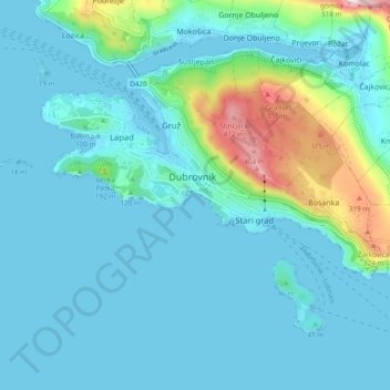
Name: Dubrovnik topographic map, elevation, terrain.

Location: Dubrovnik, Dubrovnik-Neretva County, Croatia (42.62089 18.04624 42.67056 18.14182)

Average elevation: 65 m

Minimum elevation: -4 m

Maximum elevation: 447 m

Gear up for your next adventure:

🥾Hiking Shorts - Breathable shorts suitable for summer hikes
🏕️Camping Hammock - Integrated protection for sleeping between trees
🥾Trail Hiking Boots - Supportive boots for rough trails
🧭GPS Outdoor Watch - Smart watch for navigation and fitness tracking in nature
🧥Softshell Jacket - Windproof and breathable jacket for hiking

As an Amazon Associate, this site earns from qualifying purchases at no extra cost to you.