Geolocate

Korčula topographic map

Click on the map to display elevation.

About this map
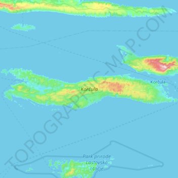
Name: Korčula topographic map, elevation, terrain.

Location: Korčula, Dubrovnik-Neretva County, Croatia (42.89342 16.62760 42.99415 17.20226)

Average elevation: 44 m

Minimum elevation: -1 m

Maximum elevation: 942 m

Other topographic maps

Click on a map to view its topography, its elevation and its terrain.
Bosanka

Croatia > Dubrovnik-Neretva County > Dubrovnik

Average elevation: 156 m

Nuga

Croatia > Dubrovnik-Neretva County > Borovci

Average elevation: 173 m

Obalj

Croatia > Dubrovnik-Neretva County > Dubrovnik

Average elevation: 376 m

Gradina

Croatia > Dubrovnik-Neretva County

Average elevation: 28 m

Orašac

Croatia > Dubrovnik-Neretva County > Dubrovnik

Average elevation: 115 m

Matijevići

Croatia > Dubrovnik-Neretva County

Average elevation: 49 m

Katani

Croatia > Dubrovnik-Neretva County > Babino Polje

Average elevation: 224 m

Radalj

Croatia > Dubrovnik-Neretva County > Klek

Average elevation: 100 m

Prijevor

Croatia > Dubrovnik-Neretva County > Dubrovnik

Average elevation: 248 m

Prižba

Croatia > Dubrovnik-Neretva County

Average elevation: 88 m

Lenga

Croatia > Dubrovnik-Neretva County > Lovište

Average elevation: 5 m

Tršić

Croatia > Dubrovnik-Neretva County > Ošlje

Average elevation: 405 m

Gear up for your next adventure:

🧭GPS Tracker - Track your location in remote areas safely
🐕Hiking Dog Pack - Let your canine companion carry their own water and food
⛺Family Camping Tent - Spacious tent suitable for family camping trips
🧤Insulated Winter Gloves - Heavy-duty protection for sub-zero Canadian adventures
🧭Orienteering Kit - Tools for map reading and navigation in the wild

As an Amazon Associate, this site earns from qualifying purchases at no extra cost to you.