
Moray topographic map
Click on the map to display elevation.
About this map
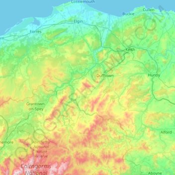
Name: Moray topographic map, elevation, terrain.
Location: Moray, Scotland, United Kingdom (57.06845 -3.76579 57.72671 -2.64982)
Average elevation: 281 m
Minimum elevation: 0 m
Maximum elevation: 1,309 m
Other topographic maps
Click on a map to view its topography, its elevation and its terrain.
Edinburgh
United Kingdom > Scotland > Edinburgh
Some have called Edinburgh the Athens of the North for a variety of reasons. The earliest comparison between the two cities showed that they had a similar topography, with the Castle Rock of Edinburgh performing a similar role to the Athenian Acropolis. Both of them had flatter, fertile agricultural land…
Average elevation: 104 m
Glasgow
United Kingdom > Scotland > Glasgow City
Glasgow itself was reputed to have been founded by the Christian missionary Saint Mungo in the 6th century. He established a church on the Molendinar Burn, where the present Glasgow Cathedral stands, and in the following years Glasgow became a religious centre. Glasgow grew over the following centuries. The…
Average elevation: 128 m
Aberdeen
United Kingdom > Scotland > Aberdeen
Two weather stations collect climate data for the area, Aberdeen/Dyce Airport, and Craibstone. Both are about 4 1⁄2 miles (7 km) to the north west of the city centre, and given that they are in close proximity to each other, exhibit very similar climatic regimes. Dyce tends to have marginally warmer daytime…
Average elevation: 52 m
Scottish Highlands
United Kingdom > Scotland > Highland
The entire region was covered by ice sheets during the Pleistocene ice ages, save perhaps for a few nunataks. The complex geomorphology includes incised valleys and lochs carved by the action of mountain streams and ice, and a topography of irregularly distributed mountains whose summits have similar heights…
Average elevation: 907 m
Fort William
United Kingdom > Scotland > Highland
Fort William has an oceanic climate (Cfb) with moderate, but generally cool, temperatures and abundant precipitation. In the towns immediate vicinity, there are significant variations in elevation, which leads to some uninhabited areas near the town having a subpolar oceanic climate (Cfc), or, at the absolute…
Average elevation: 122 m
Scottish Highlands
United Kingdom > Scotland > Highland
The Scottish Highlands are renowned for their rugged, mountainous terrain that dominates much of the region. Stretching across the northern and central parts of Scotland, the landscape is shaped by ancient geological forces, including the Caledonian Orogeny, which caused significant tectonic collisions…
Average elevation: 907 m
Falkirk
United Kingdom > Scotland > Falkirk
Falkirk is located in an area of undulating topography between the Slamannan Plateau and the upper reaches of the Firth of Forth. The area to the north of Falkirk is part of the floodplain of the River Carron. Two tributaries of the River Carron - the East Burn and the West Burn flow through the town and form…
Average elevation: 69 m
Ailsa Craig
In a small glen above Ailsa Castle, a small freshwater body known as the Garry Loch is located at an altitude of 247 m (810 ft), with a depth of at least 17 feet.
Average elevation: 14 m
Mull of Kintyre
Ailsa Craig and the County Antrim coast of Ulster and Rathlin Island are all clearly visible from the Mull. On clearer days it is also possible to make out Malin Head in Inishowen in County Donegal in the west of Ulster, and the Ayrshire coast on the other side of Ailsa Craig. Other islands in the Firth of…
Average elevation: 84 m
Dundee
United Kingdom > Scotland > Dundee City
Dundee sits on the north bank of the Firth of Tay on the eastern, North Sea Coast of Scotland. The city lies 36.1 miles (58 km) NNE of Edinburgh and 360.6 miles (580 km) NNW of London. The built-up area occupies a roughly rectangular shape 8.3 miles (13 km) long by 2.5 miles (4 km) wide, aligned in an east to…
Average elevation: 82 m
Aberlour
United Kingdom > Scotland > Moray
According to the 1846 A Topographical Dictionary of Scotland, "This parish, formerly called Skirdustan, signifying, in the Gaelic tongue, 'the division of Dustan', its tutelary saint, derived its present name from its situation at the mouth of a noisy burn, which discharges itself into the river Spey."
Average elevation: 160 m