Geolocate

Banffshire topographic map

Click on the map to display elevation.

About this map

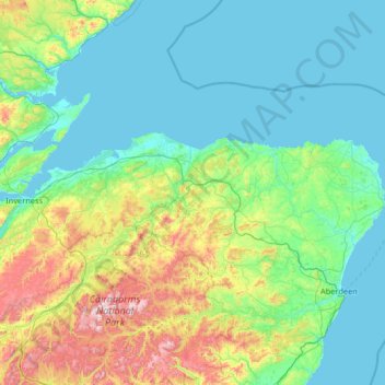
Name: Banffshire topographic map, elevation, terrain.

Location: Banffshire, Scotland, AB38 9RN, United Kingdom (56.80000 -3.78333 58.20000 -2.38333)

Average elevation: 191 m

Minimum elevation: 0 m

Maximum elevation: 1,278 m

Other topographic maps

Click on a map to view its topography, its elevation and its terrain.

City of Edinburgh

United Kingdom > Scotland

Edinburgh has been popularly called the Athens of the North since the early 19th century. References to Athens, such as Athens of Britain and Modern Athens, had been made as early as the 1760s. The similarities were seen to be topographical but also intellectual. Edinburgh's Castle Rock reminded returning…

Average elevation: 118 m

Dumfries and Galloway

United Kingdom > Scotland

Average elevation: 163 m

Skye

United Kingdom > Scotland > Highland

Beyond Loch Snizort to the west of Trotternish is the Waternish peninsula, which ends in Ardmore Point's double rock arch. Duirinish peninsula is separated from Waternish by Loch Dunvegan, which contains the island of Isay. It is ringed by sea cliffs that reach 296 metres (971 feet) on the west at Waterstein…

Average elevation: 63 m

Mull

United Kingdom > Scotland > Argyll and Bute

Average elevation: 122 m

Aberdeenshire

United Kingdom > Scotland

Average elevation: 199 m

Scottish Borders

United Kingdom > Scotland

Average elevation: 257 m

Shetland

United Kingdom > Scotland

Walter Scott's 1822 novel The Pirate is set in "a remote part of Shetland", and was inspired by his 1814 visit to the islands. The name Jarlshof meaning "Earl's Mansion" is a coinage of his. Robert Cowie, a doctor born in Lerwick published the 1874 work.Shetland: Descriptive and Historical; Being a Graduation…

Average elevation: 4 m

East Kilbride

United Kingdom > Scotland > East Kilbride

Average elevation: 177 m

Glasgow City

United Kingdom > Scotland

Average elevation: 64 m

Aberdeen City

United Kingdom > Scotland

Two weather stations collect climate data for the area, Aberdeen/Dyce Airport, and Craibstone. Both are about 4+1⁄2 miles (7 km) to the north west of the city centre, and given that they are in close proximity to each other, exhibit very similar climatic regimes. Dyce tends to have marginally warmer daytime…

Average elevation: 46 m

East Lothian

United Kingdom > Scotland

Average elevation: 132 m

Moray

United Kingdom > Scotland

Average elevation: 280 m

Lauriston

United Kingdom > Scotland > Falkirk

Average elevation: 40 m

Fife

United Kingdom > Scotland

Average elevation: 67 m

Orkney Islands

United Kingdom > Scotland

The southern group of islands surrounds Scapa Flow. Hoy, to the west, is the second largest of the Orkney Isles and Ward Hill at its northern end is the highest elevation in the archipelago. The Old Man of Hoy is a well-known seastack. Graemsay and Flotta are both linked by ferry to the Mainland and Hoy, and…

Average elevation: 7 m

South Lanarkshire

United Kingdom > Scotland

Average elevation: 289 m

Perth and Kinross

United Kingdom > Scotland

Average elevation: 338 m

Harris

United Kingdom > Scotland > Western Isles

Average elevation: 74 m

Sea of the Hebrides

United Kingdom > Scotland

Average elevation: 18 m

Dunfermline

United Kingdom > Scotland > Fife > Dunfermline

Average elevation: 80 m

West Lothian

United Kingdom > Scotland

Average elevation: 184 m

Highland

United Kingdom > Scotland

Average elevation: 183 m

Western Isles

United Kingdom > Scotland

Average elevation: 57 m

East Renfrewshire

United Kingdom > Scotland

Average elevation: 163 m

Inverclyde

United Kingdom > Scotland

Average elevation: 141 m

River Spey

United Kingdom > Scotland

Average elevation: 336 m

The Minch

United Kingdom > Scotland

Average elevation: 63 m

St Magnus' Bay

United Kingdom > Scotland

Average elevation: 6 m

Angus

United Kingdom > Scotland

Angus can be split into three geographic areas. To the north and west, the topography is mountainous. This is the area of the Grampian Mountains, Mounth hills and Five Glens of Angus, which is sparsely populated and where the main industry is hill farming. Glas Maol – the highest point in Angus at 1,068 m…

Average elevation: 254 m

Argyll and Bute

United Kingdom > Scotland

Average elevation: 84 m

Caithness

United Kingdom > Scotland

Caithness extends about 30 miles (48 km) north-south and about 30 miles (48 km) east-west, with a roughly triangular-shaped area of about 712 sq mi (1,840 km2). The topography is generally flat, in contrast to the majority of the remainder of the North of Scotland. Until the latter part of the 20th century…

Average elevation: 79 m

Isle of Arran

United Kingdom > Scotland > North Ayrshire

The island has three endemic species of tree, the Arran whitebeams. These trees are the Scottish or Arran whitebeam (Sorbus arranensis), the bastard mountain ash or cut-leaved whitebeam (Sorbus pseudofennica) and the Catacol whitebeam (Sorbus pseudomeinichii). If rarity is measured by numbers alone they are…

Average elevation: 98 m

Queen's Park

United Kingdom > Scotland > Glasgow City > Glasgow

Average elevation: 28 m

Clackmannanshire

United Kingdom > Scotland

Average elevation: 175 m

Cairngorm Mountains

United Kingdom > Scotland > Aberdeenshire

In terms of height, remoteness and the severe and changeable weather, the Cairngorms are the most arduous area in the United Kingdom. The plateau area has a Tundra climate (Köppen ET), and the shattered terrain is more like the high ground in high-arctic Canada or northern Norway than what is often observed…

Average elevation: 619 m

Loch Muick

United Kingdom > Scotland > Aberdeenshire

Average elevation: 529 m

Hebrides

United Kingdom > Scotland

Average elevation: 94 m

Islay

United Kingdom > Scotland > Argyll and Bute

Average elevation: 53 m

Lammermuirs

United Kingdom > Scotland > East Lothian

Average elevation: 266 m

Garlogie

United Kingdom > Scotland > Aberdeenshire

Average elevation: 87 m

Stirling

United Kingdom > Scotland

Average elevation: 293 m

Seil

United Kingdom > Scotland > Argyll and Bute > Clachan-Seil

Average elevation: 16 m

East Dunbartonshire

United Kingdom > Scotland

Average elevation: 161 m

West Dunbartonshire

United Kingdom > Scotland

Average elevation: 101 m

Isle of May

United Kingdom > Scotland > Fife

Average elevation: 1 m

Loch Voil

United Kingdom > Scotland > Stirling > Balquhidder

Average elevation: 370 m

Park

United Kingdom > Scotland > Western Isles

Average elevation: 100 m

Coll

United Kingdom > Scotland > Argyll and Bute > Arinagour

Average elevation: 7 m

Loch Mullardoch

United Kingdom > Scotland > Highland

Average elevation: 611 m

Loch Monar

United Kingdom > Scotland > Highland

Average elevation: 491 m

Invergarry Castle

United Kingdom > Scotland > Highland > Invergarry

The survey drawing shows a plan and elevations of the castle, called the 'Castle of Glangary' on the drawing. The drawing may appear misleading, as more than one facade is joined together, but by cross-referencing the lettering on the plan to the elevations the appearance can be judged.

Average elevation: 150 m

Kentra Bay

United Kingdom > Scotland > Highland

Average elevation: 20 m

Loch Glass

United Kingdom > Scotland > Highland

Average elevation: 430 m

Forter Castle

United Kingdom > Scotland > Angus > Folda

Average elevation: 387 m

Soay

United Kingdom > Scotland > Highland

Average elevation: 18 m

Black Loch

United Kingdom > Scotland > Falkirk > Blackloch

Average elevation: 216 m

Loch Morie

United Kingdom > Scotland > Highland

Average elevation: 327 m

Loch Cuithir

United Kingdom > Scotland > Highland

Average elevation: 245 m

Glensanda River

United Kingdom > Scotland > Highland

Average elevation: 200 m

Beinn Eighe

United Kingdom > Scotland > Highland

Beinn Eighe (Scottish Gaelic for 'file mountain') is a mountain massif in the Torridon area of Wester Ross in the Northwest Highlands of Scotland. Lying south of Loch Maree, it forms a long ridge with many spurs and summits, two of which are classified as Munros: Ruadh-stac Mòr at 1,010 m (3,314 ft) and…

Average elevation: 633 m

Quinag

United Kingdom > Scotland > Highland

Average elevation: 368 m

Rhinns of Kellsc

United Kingdom > Scotland > Dumfries and Galloway

'Rhinns' derives from the Old Irish rind, later Ulster Irish and Scottish Gaelic rinn, meaning 'promontory' or 'point'. 'Kells' is a parish in the historic county of Stewartry of Kirkcudbright to the southeast of the range near New Galloway. Its name possibly derives from the Old Irish cell, later Irish and…

Average elevation: 352 m

Moffat Hills

United Kingdom > Scotland > Scottish Borders > Tweedsmuir

The Megget Stane (OS. Ref. NT152203) is by a cattle grid at the highest point between the Talla and Megget reservoirs on the minor road which runs from Tweedsmuir on the A701 to Cappercleuch by shore of St Mary's Loch. It is quite easy to miss the stone when coming from Talla as it is hidden by a gate. At an…

Average elevation: 430 m

River Teith

United Kingdom > Scotland > Stirling > Callander

Average elevation: 96 m

River Earn

United Kingdom > Scotland > Perth and Kinross

Average elevation: 221 m

River Forth

United Kingdom > Scotland > Falkirk

Average elevation: 140 m

River Doon

United Kingdom > Scotland > East Ayrshire > Dalrymple

Average elevation: 168 m

River Ayr

United Kingdom > Scotland > East Ayrshire

Average elevation: 210 m

River Etive

United Kingdom > Scotland > Highland

Average elevation: 472 m

River Lochy

United Kingdom > Scotland > Highland > Fort William

Average elevation: 155 m

River Findhorn

United Kingdom > Scotland > Highland

Average elevation: 278 m

River Lossie

United Kingdom > Scotland > Moray

Average elevation: 135 m

River Deveron

United Kingdom > Scotland > Moray

Average elevation: 167 m

River Ythan

United Kingdom > Scotland > Aberdeenshire

Average elevation: 104 m

River Ugie

United Kingdom > Scotland > Aberdeenshire > Inverugie

Average elevation: 30 m

River North Esk

United Kingdom > Scotland > Angus

Average elevation: 204 m

Gear up for your next adventure:

🔦LED Headlamp - Hands-free lighting for early morning starts or late finishes
Family Camping Tent - Spacious tent suitable for family camping trips
Camping Essentials - All-in-one gear for a comfortable camping trip
🧊Insulated Water Bottle - Keeps drinks cold in summer and prevents freezing in winter
Tent Footprint - Protect tent floor and increase durability

As an Amazon Associate, this site earns from qualifying purchases at no extra cost to you.