Geolocate

Strathclyde Park topographic map

Click on the map to display elevation.

About this map

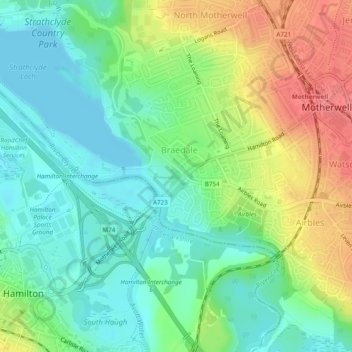
Name: Strathclyde Park topographic map, elevation, terrain.

Location: Strathclyde Park, Braedale, Motherwell, North Lanarkshire, Scotland, ML1, United Kingdom (55.78410 -4.01641 55.78577 -4.01194)

Average elevation: 44 m

Minimum elevation: 18 m

Maximum elevation: 86 m

Other topographic maps

Click on a map to view its topography, its elevation and its terrain.

Gear up for your next adventure:

Camping Groundsheet - Protect your tent from moisture and dirt
🎒Hiking Backpack - Lightweight and ergonomic backpacks for day hikes or multi-day treks
🪑Ultralight Camping Stool - Compact seating for rest stops during long hikes
📷Outdoor Action Camera - Capture high-elevation views and rugged adventures
💧Hydration Pack - Hands-free hydration system for long hikes

As an Amazon Associate, this site earns from qualifying purchases at no extra cost to you.