Geolocate

Ayr topographic map

Click on the map to display elevation.

About this map

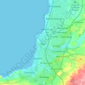
Name: Ayr topographic map, elevation, terrain.

Location: Ayr, South Ayrshire, Scotland, KA7 1NE, United Kingdom (55.42280 -4.67025 55.50280 -4.59025)

Average elevation: 18 m

Minimum elevation: -1 m

Maximum elevation: 120 m

Other topographic maps

Click on a map to view its topography, its elevation and its terrain.

Gear up for your next adventure:

🧶550 Survival Paracord - Versatile utility cord for emergency repairs and rigging
💧Hydration Bladder - Hands-free hydration solution for long treks
🧦Outdoor Socks - Durable socks designed for hiking and outdoor sports
🛶Canoe Life Vest - Safety vest for water sports
🧦Hiking Liner Socks - Thin base layer to prevent friction and blisters

As an Amazon Associate, this site earns from qualifying purchases at no extra cost to you.