
Area C (Butedale/Kitlope/Kitsumkalum) topographic map
Interactive map
Click on the map to display elevation.
About this map
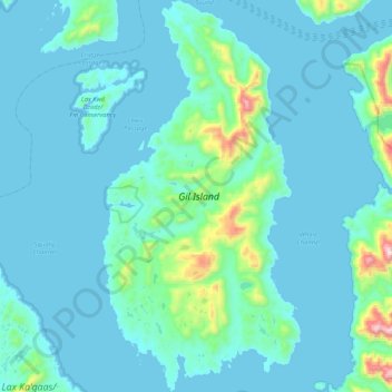
Name: Area C (Butedale/Kitlope/Kitsumkalum) topographic map, elevation, terrain.
Average elevation: 88 m
Minimum elevation: 0 m
Maximum elevation: 974 m
Regional District of Kitimat-Stikine trails, hiking, mountain biking, running and outdoor activities
Other topographic maps
Click on a map to view its topography, its elevation and its terrain.
Mount Edziza
Canada > British Columbia > Regional District of Kitimat-Stikine > Area D (Iskut/Big Raven)
Mount Edziza (/ədˈzaɪzə/ əd-ZY-zə; Tahltan: Tenh Dẕetle [ten̥ ˈdðetle]) is a volcanic mountain in Cassiar Land District of northwestern British Columbia, Canada. It is located on the Big Raven Plateau of the Tahltan Highland which extends along the western side of the Stikine Plateau. Mount Edziza…
Average elevation: 2,530 m
Kitsault
Canada > British Columbia > Regional District of Kitimat-Stikine > Area A (Nass Valley/Bell Irving)
Average elevation: 155 m
Eve Cone
Canada > British Columbia > Regional District of Kitimat-Stikine > Area D (Iskut/Big Raven)
Eve Cone, sometimes referred to as Eve's Cone, is a cinder cone in Cassiar Land District of northwestern British Columbia, Canada. It has an elevation of 1,740 metres (5,710 feet) and is one of several volcanic cones in the Desolation Lava Field at the northern end of the Big Raven Plateau. The cone is…
Average elevation: 1,607 m
Anyox
Canada > British Columbia > Regional District of Kitimat-Stikine > Area A (Nass Valley/Bell Irving)
Average elevation: 110 m
Devils Thumb
Canada > British Columbia > Regional District of Kitimat-Stikine > Area D (Iskut/Big Raven)
Average elevation: 1,718 m
Mount Dalton
Canada > British Columbia > Regional District of Kitimat-Stikine > Area F (Dease Lake)
Average elevation: 1,658 m
Devils Thumb
Canada > British Columbia > Regional District of Kitimat-Stikine > Area D (Iskut/Big Raven)
Average elevation: 1,718 m
Deep Creek
Canada > British Columbia > Regional District of Kitimat-Stikine > Area C (Butedale/Kitlope/Kitsumkalum)
Average elevation: 133 m
Thornhill
Canada > British Columbia > Regional District of Kitimat-Stikine > Area E (Thornhill)
Average elevation: 117 m
Atna Peak
Canada > British Columbia > Regional District of Kitimat-Stikine > Area C (Butedale/Kitlope/Kitsumkalum)
Average elevation: 2,075 m
Hagwilget
Canada > British Columbia > Regional District of Kitimat-Stikine > Area B (Suskwa/Kitwanga/Kispiox)
Average elevation: 337 m
Iskut
Canada > British Columbia > Regional District of Kitimat-Stikine > Area D (Iskut/Big Raven)
Average elevation: 930 m
40 Mile Flats
Canada > British Columbia > Regional District of Kitimat-Stikine > Area D (Iskut/Big Raven)
Average elevation: 1,105 m
Klemtu
Canada > British Columbia > Regional District of Kitimat-Stikine > Area C (Butedale/Kitlope/Kitsumkalum)
Average elevation: 152 m
Pentz Lake
Canada > British Columbia > Regional District of Kitimat-Stikine > Area B (Suskwa/Kitwanga/Kispiox)
Average elevation: 356 m
Meziadin Fishway
Canada > British Columbia > Regional District of Kitimat-Stikine > Area A (Nass Valley/Bell Irving)
Average elevation: 261 m
Beaver Lake
Canada > British Columbia > Regional District of Kitimat-Stikine > Area F (Dease Lake) > Dease Lake
Average elevation: 865 m
Clearwater Lakes
Canada > British Columbia > Regional District of Kitimat-Stikine > Area C (Butedale/Kitlope/Kitsumkalum)
Average elevation: 200 m
Dease Lake
Canada > British Columbia > Regional District of Kitimat-Stikine > Area F (Dease Lake)
Dease Lake has a subarctic climate (Köppen Dfc), typical of northern British Columbia. Summers are mild, coupled with chilly nights while winters are severely cold and snowy, with annual snowfall averaging 212.8 cm (83.78 in). Autumn typically begins by early September and lasts into October when winter…
Average elevation: 898 m
Alice Arm
Canada > British Columbia > Regional District of Kitimat-Stikine > Area A (Nass Valley/Bell Irving)
Average elevation: 186 m
Affleck Lake
Canada > British Columbia > Regional District of Kitimat-Stikine > Area B (Suskwa/Kitwanga/Kispiox)
Average elevation: 417 m
Terrace
Canada > British Columbia > Regional District of Kitimat-Stikine > Terrace > Terrace
Average elevation: 121 m
Sixteen Mile Creek
Canada > British Columbia > Regional District of Kitimat-Stikine > Area F (Dease Lake)
Average elevation: 1,267 m
Hazelton
Canada > British Columbia > Regional District of Kitimat-Stikine > Hazelton > Hazelton
Average elevation: 266 m
Bell II
Canada > British Columbia > Regional District of Kitimat-Stikine > Area A (Nass Valley/Bell Irving) > Bell II
Average elevation: 673 m
Kitwanga
Canada > British Columbia > Regional District of Kitimat-Stikine > Area B (Suskwa/Kitwanga/Kispiox) > Kitwanga
Average elevation: 329 m
Ball Creek
Canada > British Columbia > Regional District of Kitimat-Stikine > Area F (Dease Lake)
Average elevation: 1,267 m
Iskut River
Canada > British Columbia > Regional District of Kitimat-Stikine > Area D (Iskut/Big Raven)
Average elevation: 932 m
Hoodoo Mountain
Canada > British Columbia > Regional District of Kitimat-Stikine > Area D (Iskut/Big Raven)
Hoodoo Mountain, sometimes referred to as Hoodoo Volcano, is a potentially active stratovolcano in the Northern Interior of British Columbia, Canada. It is located 25 kilometres (16 miles) northeast of the Alaska–British Columbia border on the north side of the Iskut River opposite of the mouth of the Craig…
Average elevation: 1,657 m
South Hazelton
Canada > British Columbia > Regional District of Kitimat-Stikine > Area B (Suskwa/Kitwanga/Kispiox) > South Hazelton
Average elevation: 278 m
Kitselas
Canada > British Columbia > Regional District of Kitimat-Stikine > Area C (Butedale/Kitlope/Kitsumkalum) > Kitselas
Average elevation: 226 m
Tseax Cone
Canada > British Columbia > Regional District of Kitimat-Stikine > Area A (Nass Valley/Bell Irving)
Average elevation: 723 m