
Make a donation
Gear up for your next adventure:
As an Amazon Associate, this site earns from qualifying purchases at no extra cost to you.
Ball Creek topographic map
Click on the map to display elevation.
Make a donation
Gear up for your next adventure:
As an Amazon Associate, this site earns from qualifying purchases at no extra cost to you.
About this map
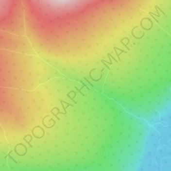
Name: Ball Creek topographic map, elevation, terrain.
Average elevation: 1,267 m
Minimum elevation: 1,043 m
Maximum elevation: 1,502 m
Regional District of Kitimat-Stikine trails, hiking, mountain biking, running and outdoor activities
Make a donation
Gear up for your next adventure:
As an Amazon Associate, this site earns from qualifying purchases at no extra cost to you.
Other topographic maps
Click on a map to view its topography, its elevation and its terrain.
Dease Lake
Canada > British Columbia > Regional District of Kitimat-Stikine > Area F (Dease Lake)
Dease Lake has a subarctic climate (Köppen Dfc), typical of northern British Columbia. Summers are mild, coupled with chilly nights while winters are severely cold and snowy, with annual snowfall averaging 212.8 cm (83.78 in). Autumn typically begins by early September and lasts into October when winter…
Average elevation: 898 m
Dease Lake
Canada > British Columbia > Regional District of Kitimat-Stikine > Area F (Dease Lake)
Average elevation: 1,128 m
Mount Dalton
Canada > British Columbia > Regional District of Kitimat-Stikine > Area F (Dease Lake)
Average elevation: 1,658 m