
Make a donation
Gear up for your next adventure:
As an Amazon Associate, this site earns from qualifying purchases at no extra cost to you.
City of Fredericton topographic map
Click on the map to display elevation.
Make a donation
Gear up for your next adventure:
As an Amazon Associate, this site earns from qualifying purchases at no extra cost to you.
City of Fredericton
At an altitude of about 17 m (56 ft) above sea level, Fredericton is nestled in the Pennsylvanian Basin. It differs markedly from the geologically older parts of the province. There are prominently two distinct areas in the region that are divided around the area of Wilsey Road, in the east end of the city. In the west side, the bedrock underneath the earth is topographically dominant, whereas the other is controlled by Pleistocene and recent deposits leading to the rivers (resulting in the area being shallow and wide). Fredericton and its surroundings are rich in water resources, which, coupled with highly arable soil, make the Fredericton region ideal for agriculture. The Saint John River and one of its major tributaries, the Nashwaak River, come together in Fredericton. The uninhabited parts of the city are heavily forested.
Make a donation
Gear up for your next adventure:
As an Amazon Associate, this site earns from qualifying purchases at no extra cost to you.
About this map
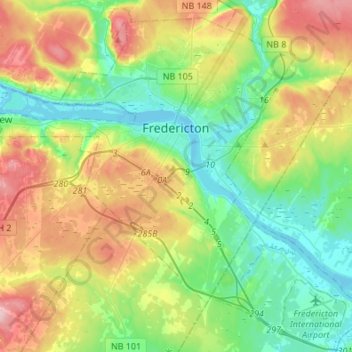
Name: City of Fredericton topographic map, elevation, terrain.
Location: City of Fredericton, York County, New Brunswick, Canada (45.84701 -66.78705 46.05046 -66.51199)
Average elevation: 71 m
Minimum elevation: -2 m
Maximum elevation: 191 m
New Brunswick trails, hiking, mountain biking, running and outdoor activities
Make a donation
Gear up for your next adventure:
As an Amazon Associate, this site earns from qualifying purchases at no extra cost to you.
Other topographic maps
Click on a map to view its topography, its elevation and its terrain.
Dunbar Falls
Canada > New Brunswick > Nashwaak Rural Community > Saint Marys Parish
Average elevation: 67 m
Harley Road
Canada > New Brunswick > Municipality of Grand Lake > Chipman Parish
Average elevation: 65 m
Make a donation
Gear up for your next adventure:
As an Amazon Associate, this site earns from qualifying purchases at no extra cost to you.
Bunker Hill
Canada > New Brunswick > Rural Community of Campobello Island > Campobello Parish
Average elevation: 24 m
Handren Hill
Canada > New Brunswick > Saint John County > Village of Fundy-St. Martins
Average elevation: 180 m
Simpson Corner
Canada > New Brunswick > Charlotte County > Municipal District of St. Stephen
Average elevation: 27 m
Make a donation
Gear up for your next adventure:
As an Amazon Associate, this site earns from qualifying purchases at no extra cost to you.
Cap-Pelé
Canada > New Brunswick > Regional Town of Cap-Acadie > Botsford Parish
Average elevation: 12 m
Make a donation
Gear up for your next adventure:
As an Amazon Associate, this site earns from qualifying purchases at no extra cost to you.
Saint John River
Canada > New Brunswick > Haut-Madawaska > Saint-Francois Parish > Saint-François-de-Madawaska
The eastern Algonquin languages had different dialects associated with each of the major river systems of New England and the Maritimes; and there was often a linguistic bifurcation between residents of the upper river and those living along the coast and tidal estuary. The Passamaquoddy hunted sea mammals…
Average elevation: 208 m
Crombie Settlement
Canada > New Brunswick > District of Tobique Valley > Gordon Parish
Average elevation: 255 m
Make a donation
Gear up for your next adventure:
As an Amazon Associate, this site earns from qualifying purchases at no extra cost to you.
Cameron Mountain Range
Canada > New Brunswick > Western Valley Rural District > Lorne Parish
Average elevation: 363 m
Saint-Isidore
Canada > New Brunswick > Municipality of Hautes-Terres > Saint-Isidore Parish
Average elevation: 58 m
Saint-Pons
Canada > New Brunswick > Gloucester County > Regional Municipality of Tracadie
Average elevation: 23 m
Make a donation
Gear up for your next adventure:
As an Amazon Associate, this site earns from qualifying purchases at no extra cost to you.
Martin Head
Canada > New Brunswick > Fundy Rural District > Saint Martins Parish
Average elevation: 7 m
Saint-André
Canada > New Brunswick > Madawaska County > Grand Falls Regional Municipality
Average elevation: 220 m
Make a donation
Gear up for your next adventure:
As an Amazon Associate, this site earns from qualifying purchases at no extra cost to you.
South Knowlesville
Canada > New Brunswick > Carleton County > Town of Hartland
Average elevation: 285 m
Saint-Sauveur
Canada > New Brunswick > Municipality of Hautes-Terres > Allardville Parish
Average elevation: 89 m
Make a donation
Gear up for your next adventure:
As an Amazon Associate, this site earns from qualifying purchases at no extra cost to you.
Heathland
Canada > New Brunswick > Charlotte County > Municipal District of St. Stephen
Average elevation: 64 m
Bouctouche
Canada > New Brunswick > Town of Grand-Bouctouche > Wellington Parish
Average elevation: 17 m
Cap-Pelé
Canada > New Brunswick > Regional Town of Cap-Acadie > Botsford Parish
Average elevation: 12 m
Make a donation
Gear up for your next adventure:
As an Amazon Associate, this site earns from qualifying purchases at no extra cost to you.
Havelock
Canada > New Brunswick > Butternut Valley Rural Community > Havelock Parish
Average elevation: 93 m
Make a donation
Gear up for your next adventure:
As an Amazon Associate, this site earns from qualifying purchases at no extra cost to you.
Haneytown
Canada > New Brunswick > Capital Region Rural District > Burton Parish
Average elevation: 21 m
Blackville
Canada > New Brunswick > Rural Community of Miramichi River Valley > Blackville Parish
Average elevation: 45 m
Grande-Digue
Canada > New Brunswick > Rural Community of Beausoleil > Dundas Parish
Average elevation: 13 m
Make a donation
Gear up for your next adventure:
As an Amazon Associate, this site earns from qualifying purchases at no extra cost to you.
Bartibog Bridge
Canada > New Brunswick > Municipality of Alnwick > Alnwick Parish
Average elevation: 12 m
Make a donation
Gear up for your next adventure:
As an Amazon Associate, this site earns from qualifying purchases at no extra cost to you.
Blackville
Canada > New Brunswick > Rural Community of Miramichi River Valley > Blackville Parish
Average elevation: 45 m
Perth-Andover
Canada > New Brunswick > Village of Southern Victoria > Andover Parish
Average elevation: 196 m
Make a donation
Gear up for your next adventure:
As an Amazon Associate, this site earns from qualifying purchases at no extra cost to you.
Millville
Canada > New Brunswick > Nackawic-Millville Rural Community > Southampton Parish
Average elevation: 169 m
Memramcook Lake
Canada > New Brunswick > Westmorland County > Dorchester Parish
Average elevation: 19 m
Porter Road
Canada > New Brunswick > Village of Fundy-St. Martins > Saint Martins Parish
Average elevation: 136 m
Make a donation
Gear up for your next adventure:
As an Amazon Associate, this site earns from qualifying purchases at no extra cost to you.
Keswick Ridge
Canada > New Brunswick > Central York Rural Community > Bright Parish
Average elevation: 43 m
Make a donation
Gear up for your next adventure:
As an Amazon Associate, this site earns from qualifying purchases at no extra cost to you.
Make a donation
Gear up for your next adventure:
As an Amazon Associate, this site earns from qualifying purchases at no extra cost to you.
Make a donation
Gear up for your next adventure:
As an Amazon Associate, this site earns from qualifying purchases at no extra cost to you.
Make a donation
Gear up for your next adventure:
As an Amazon Associate, this site earns from qualifying purchases at no extra cost to you.
Make a donation
Gear up for your next adventure:
As an Amazon Associate, this site earns from qualifying purchases at no extra cost to you.
Make a donation
Gear up for your next adventure:
As an Amazon Associate, this site earns from qualifying purchases at no extra cost to you.
Make a donation
Gear up for your next adventure:
As an Amazon Associate, this site earns from qualifying purchases at no extra cost to you.
Make a donation
Gear up for your next adventure:
As an Amazon Associate, this site earns from qualifying purchases at no extra cost to you.
Make a donation
Gear up for your next adventure:
As an Amazon Associate, this site earns from qualifying purchases at no extra cost to you.
Edmundston
Canada > New Brunswick > Edmundston
Edmundston has a downhill skiing facility in the city at Mont Farlagne. This facility has 3 lifts, a t-bar, a double chair, and a quad chair. It has 14 trails and an elevation of 690 feet. Snowmaking is available. Five trails are lit for night skiing.
Average elevation: 256 m
Make a donation
Gear up for your next adventure:
As an Amazon Associate, this site earns from qualifying purchases at no extra cost to you.
Make a donation
Gear up for your next adventure:
As an Amazon Associate, this site earns from qualifying purchases at no extra cost to you.
Make a donation
Gear up for your next adventure:
As an Amazon Associate, this site earns from qualifying purchases at no extra cost to you.