
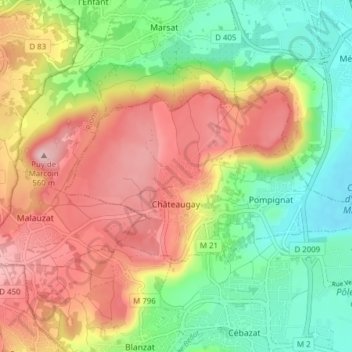
Châteaugay topographic map
Click on the map to display elevation.
About this map
Name: Châteaugay topographic map, elevation, terrain.
Average elevation: 426 m
Minimum elevation: 316 m
Maximum elevation: 552 m
Other topographic maps
Click on a map to view its topography, its elevation and its terrain.
Puy de Gravenoire
France > Auvergne-Rhône-Alpes > Puy-de-Dôme > Royat
Le puy de Gravenoire constitue une proéminence du plateau situé à l'est de la Limagne, dans le prolongement du puy de Charade. Culminant à 821 mètres d'altitude, il est de forme arrondie aux flancs entaillés par l'exploitation de scories de couleur rouge à noire provenant de l'ancienne activité…
Average elevation: 654 m
Puy de la Vache
France > Auvergne-Rhône-Alpes > Puy-de-Dôme > Saint-Genès-Champanelle
Le puy de la Vache est situé sur la commune de Saint-Genès-Champanelle, au sud-ouest de Clermont-Ferrand. Il culmine à 1 167 mètres d'altitude. Sa principale coulée de lave, conjointe à celle du puy de Lassolas est dénommée cheire d'Aydat. Elle a créé, en barrant des vallées, différents lacs dont…
Average elevation: 1,007 m
Col de la Ventouse
France > Auvergne-Rhône-Alpes > Puy-de-Dôme > Aydat
Le col de la Ventouse est un col routier du Massif central, situé sur le territoire communal d'Aydat, dans le département du Puy-de-Dôme, en région Auvergne-Rhône-Alpes. Il s'élève à 964 m d'altitude (les panneaux indiquent 980 m). Il est dominé par le puy de Vichatel (1 095 m), au nord-ouest, et le…
Average elevation: 951 m
Puy de Sancy
France > Auvergne-Rhône-Alpes > Puy-de-Dôme > Mont-Dore
Le puy de Sancy est un sommet des monts Dore situé dans le département du Puy-de-Dôme, à 35 kilomètres au sud-ouest de Clermont-Ferrand. C'est, avec ses 1 885 mètres d'altitude, le point culminant du Massif central et le plus haut volcan en France métropolitaine.
Average elevation: 1,601 m
Château de Codignat
France > Auvergne-Rhône-Alpes > Puy-de-Dôme > Bort-l'Étang > Chez Taloup
Average elevation: 374 m
Puy de Dôme
France > Auvergne-Rhône-Alpes > Puy-de-Dôme > Orcines
Le puy de Dôme, comme tous les volcans de la chaîne des Puys, repose sur un plateau granitique (socle cristallin) situé à un peu moins de 1 000 mètres d’altitude. Il s’agit d’un ancien dôme de lave de forme tronconique. Haut de 550 mètres et large de deux kilomètres à la base, son sommet culmine…
Average elevation: 1,067 m
Douhady
France > Auvergne-Rhône-Alpes > Puy-de-Dôme > Charbonnières-les-Varennes
Average elevation: 692 m
Les Beaudards
France > Auvergne-Rhône-Alpes > Puy-de-Dôme > Varennes-sur-Usson
Average elevation: 402 m
Ludieres
France > Auvergne-Rhône-Alpes > Puy-de-Dôme > Le Vernet-Sainte-Marguerite
Average elevation: 990 m
Montgiraud
France > Auvergne-Rhône-Alpes > Puy-de-Dôme > Saint-Éloy-les-Mines
Average elevation: 557 m
Chabassiere
France > Auvergne-Rhône-Alpes > Puy-de-Dôme > Saint-Gervais-d'Auvergne
Average elevation: 647 m
Belvédère de Navoirat
France > Auvergne-Rhône-Alpes > Puy-de-Dôme > Menat > Les Chaumettes
Average elevation: 449 m
Château de Saint-Saturnin
France > Auvergne-Rhône-Alpes > Puy-de-Dôme > Saint-Saturnin > Issac
Average elevation: 557 m
Mascortel
France > Auvergne-Rhône-Alpes > Puy-de-Dôme > Saint-Clément-de-Valorgue
Average elevation: 1,002 m
Parc de Montjuzet
France > Auvergne-Rhône-Alpes > Puy-de-Dôme > Clermont-Ferrand
Average elevation: 437 m
Vassivière
France > Auvergne-Rhône-Alpes > Puy-de-Dôme > Besse-et-Saint-Anastaise
Average elevation: 1,283 m
Panorama sur le lac Chambon
France > Auvergne-Rhône-Alpes > Puy-de-Dôme > Chambon-sur-Lac
Average elevation: 950 m
Puy de Chanturgue
France > Auvergne-Rhône-Alpes > Puy-de-Dôme > Clermont-Ferrand
Average elevation: 422 m
Bordas
France > Auvergne-Rhône-Alpes > Puy-de-Dôme > Rochefort-Montagne > Bomparent
Average elevation: 929 m
Ourcière
France > Auvergne-Rhône-Alpes > Puy-de-Dôme > Saint-Pierre-Colamine > Lomprat
Average elevation: 972 m
Paugnat
France > Auvergne-Rhône-Alpes > Puy-de-Dôme > Charbonnières-les-Varennes
Average elevation: 791 m
Lac de Guéry
France > Auvergne-Rhône-Alpes > Puy-de-Dôme > Mont-Dore
Situé à une altitude de 1 244 m, ce lac de 25 hectares est dû à une coulée de lave qui a barré le cours d'un torrent venu du puy Gros. Il est de forme presque parfaitement ovale, et peu profond puisque sa profondeur maximum est de 18 m.
Average elevation: 1,311 m
Creux de Fouilloux
France > Auvergne-Rhône-Alpes > Puy-de-Dôme > Saint-Étienne-sur-Usson
Average elevation: 600 m