Geolocate

Les Longes topographic map

Click on the map to display elevation.

About this map

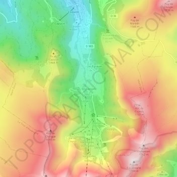
Name: Les Longes topographic map, elevation, terrain.

Location: Les Longes, Mont-Dore, Issoire, Puy-de-Dôme, Auvergne-Rhône-Alpes, France métropolitaine, 63240, France (45.53308 2.79406 45.57308 2.83406)

Average elevation: 1,420 m

Minimum elevation: 1,044 m

Maximum elevation: 1,771 m

Other topographic maps

Click on a map to view its topography, its elevation and its terrain.

Lac de Guéry

France > Auvergne-Rhône-Alpes > Puy-de-Dôme > Mont-Dore

Situé à une altitude de 1 244 m, ce lac de 25 hectares est dû à une coulée de lave qui a barré le cours d'un torrent venu du puy Gros. Il est de forme presque parfaitement ovale, et peu profond puisque sa profondeur maximum est de 18 m.

Average elevation: 1,311 m

Gear up for your next adventure:

🥾Waterproof Hiking Shoes - Durable shoes for wet and rugged trails
👟Trail Running Shoes - Agile footwear for fast-paced topographic exploration
🦌Outdoor Trail Camera - Monitor wildlife activity near your favorite spots
🔋Emergency Crank Radio - Weather alerts and power without needing batteries
🦶Anti-Blister Balm - Prevents friction and hotspots during long ascents

As an Amazon Associate, this site earns from qualifying purchases at no extra cost to you.