
Gergovie topographic map
Click on the map to display elevation.
About this map
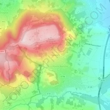
Name: Gergovie topographic map, elevation, terrain.
Average elevation: 512 m
Minimum elevation: 344 m
Maximum elevation: 742 m
Other topographic maps
Click on a map to view its topography, its elevation and its terrain.
Plateau de Gergovie
France > Auvergne-Rhône-Alpes > Puy-de-Dôme > La Roche-Blanche
Le plateau de Gergovie (autrefois appelé « plaine de Merdogne ») est un plateau de 70 hectares à 744 mètres d'altitude, situé à une dizaine de kilomètres au sud de Clermont-Ferrand, dans le Puy-de-Dôme, en Auvergne. C'est le lieu où se trouvait l'oppidum gaulois de Gergovie, célèbre pour son siège…
Average elevation: 585 m