Geolocate

Mezel topographic map

Click on the map to display elevation.

About this map

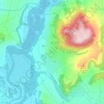
Name: Mezel topographic map, elevation, terrain.

Location: Mezel, Mur-sur-Allier, Clermont-Ferrand, Puy-de-Dôme, Auvergne-Rhône-Alpes, France métropolitaine, 63115, France (45.73684 3.22170 45.77684 3.26170)

Average elevation: 387 m

Minimum elevation: 309 m

Maximum elevation: 595 m

Other topographic maps

Click on a map to view its topography, its elevation and its terrain.

Mezel

France > Auvergne-Rhône-Alpes > Puy-de-Dôme > Mur-sur-Allier

Le 25 janvier 1949, un météoroïde explose à environ 12 km d'altitude, projetant quatre fragments retrouvés par Pierre Berlande, un Mezellois de 17 ans. La météorite de Mezel est une chondrite de type L6.

Average elevation: 376 m

Gear up for your next adventure:

🥾Trail Running Boots - Durable shoes designed for trail running
🚑Survival Whistle - Signal for help across long distances in mountains
🛏️Sleeping Bag - Warm and compact sleeping bags for outdoor camping
🕶️Polarized Sunglasses - Protect your eyes with durable polarized lenses
🧭GPS Tracker - Track your location in remote areas safely

As an Amazon Associate, this site earns from qualifying purchases at no extra cost to you.