Geolocate

Sommet topographic map

Click on the map to display elevation.

About this map

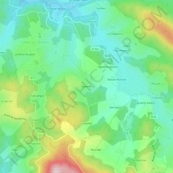
Name: Sommet topographic map, elevation, terrain.

Location: Sommet, Celles-sur-Durolle, Thiers, Puy-de-Dôme, Auvergne-Rhône-Alpes, France métropolitaine, 63250, France (45.82754 3.63250 45.86754 3.67250)

Average elevation: 669 m

Minimum elevation: 568 m

Maximum elevation: 888 m

Other topographic maps

Click on a map to view its topography, its elevation and its terrain.

Gear up for your next adventure:

🧢Beanie Hat - Keep your head warm in cold weather
🥾Light Trekking Boots - Supportive boots for multi-day treks
🥾Trail Running Shoes - Lightweight and durable shoes for trail running
🥾Mountaineering Boots - Supportive boots for climbing and high-altitude hiking
🥫Freeze-Dried Meals - Lightweight, high-calorie nutrition for multi-day treks

As an Amazon Associate, this site earns from qualifying purchases at no extra cost to you.