Make a donation
Gear up for your next adventure:
As an Amazon Associate, this site earns from qualifying purchases at no extra cost to you.
Hamedan topographic map
Click on the map to display elevation.
Make a donation
Gear up for your next adventure:
As an Amazon Associate, this site earns from qualifying purchases at no extra cost to you.
About this map
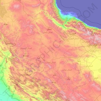
Name: Hamedan topographic map, elevation, terrain.
Location: Hamedan, Iran (32.83231 45.96651 38.03231 51.16651)
Average elevation: 1,465 m
Minimum elevation: -31 m
Maximum elevation: 4,553 m
Make a donation
Gear up for your next adventure:
As an Amazon Associate, this site earns from qualifying purchases at no extra cost to you.
Other topographic maps
Click on a map to view its topography, its elevation and its terrain.
Mazandaran Province
Mazandaran province naturally comes under the influence of the geographical latitude, Alborz heights, elevation from sea level, distance from the sea, and the southern barren areas of Turkmenistan, local and regional air currents, and versatile vegetation cover. Therefore, prompting the climate of the province…
Average elevation: 863 m
Make a donation
Gear up for your next adventure:
As an Amazon Associate, this site earns from qualifying purchases at no extra cost to you.
Kerman Province
The altitudes and heights of the province are the continuation of the central mountain ranges of Iran. They extend from the volcanic folds beginning in Azerbaijan and, by branching out in the central plateau of Iran, terminate in Baluchestan. These mountain ranges have brought about vast plains in the…
Average elevation: 1,150 m
Make a donation
Gear up for your next adventure:
As an Amazon Associate, this site earns from qualifying purchases at no extra cost to you.
Make a donation
Gear up for your next adventure:
As an Amazon Associate, this site earns from qualifying purchases at no extra cost to you.
Make a donation
Gear up for your next adventure:
As an Amazon Associate, this site earns from qualifying purchases at no extra cost to you.
Make a donation
Gear up for your next adventure:
As an Amazon Associate, this site earns from qualifying purchases at no extra cost to you.
Make a donation
Gear up for your next adventure:
As an Amazon Associate, this site earns from qualifying purchases at no extra cost to you.
Make a donation
Gear up for your next adventure:
As an Amazon Associate, this site earns from qualifying purchases at no extra cost to you.
دهستان نازلوشمالی
Iran > West Azerbaijan Province > Urumia County > دهستان نازلوشمالی
Average elevation: 1,432 m
دهستان سفید دشت
Iran > Isfahan Province > Aran and Bidgol County > دهستان سفید دشت
Average elevation: 919 m
Make a donation
Gear up for your next adventure:
As an Amazon Associate, this site earns from qualifying purchases at no extra cost to you.
Sar Khun, Chaharmahal and Bakhtiari
Iran > Chaharmahal and Bakhtiyari Province > Ardal County
Average elevation: 1,622 m
Make a donation
Gear up for your next adventure:
As an Amazon Associate, this site earns from qualifying purchases at no extra cost to you.
Shahrud
Iran > Semnan Province > Shahrud County
Situated about an altitude of 1345 m, it is located at latitude 36°25'N, longitude 055°01'E. The main launch site of the Iranian Space Agency is near Shahrood. It is also well known for unique types of grapes which are cultivated specially in Shahrud. Consequently, Shahrood is known as the City of Grapes.
Average elevation: 1,375 m
