Make a donation
Gear up for your next adventure:
As an Amazon Associate, this site earns from qualifying purchases at no extra cost to you.
Fars Province topographic map
Click on the map to display elevation.
Make a donation
Gear up for your next adventure:
As an Amazon Associate, this site earns from qualifying purchases at no extra cost to you.
About this map
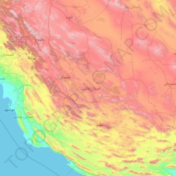
Name: Fars Province topographic map, elevation, terrain.
Location: Fars Province, Iran (27.06802 50.60318 31.66964 55.73296)
Average elevation: 1,339 m
Minimum elevation: -2 m
Maximum elevation: 4,174 m
Make a donation
Gear up for your next adventure:
As an Amazon Associate, this site earns from qualifying purchases at no extra cost to you.
Other topographic maps
Click on a map to view its topography, its elevation and its terrain.
Make a donation
Gear up for your next adventure:
As an Amazon Associate, this site earns from qualifying purchases at no extra cost to you.
Amlash
Iran > Gilan Province > Amlash County > دهستان املش شمالی
Amlash (Persian: املش) is a city in the Central District of Amlash County, Gilan province, in northwestern Iran, serving as the capital of both the county and the district. Amlash sits at an altitude of 13 metres (45 feet).
Average elevation: 66 m
Make a donation
Gear up for your next adventure:
As an Amazon Associate, this site earns from qualifying purchases at no extra cost to you.
Make a donation
Gear up for your next adventure:
As an Amazon Associate, this site earns from qualifying purchases at no extra cost to you.
پایین شالینگچال
Iran > Mazandaran Province > Babol County > دهستان فیروزجاه
Average elevation: 2,077 m
Make a donation
Gear up for your next adventure:
As an Amazon Associate, this site earns from qualifying purchases at no extra cost to you.
Make a donation
Gear up for your next adventure:
As an Amazon Associate, this site earns from qualifying purchases at no extra cost to you.
Sabalan
Iran > Ardabil Province > Meshkinshahr County > دهستان لاهرود
At 4,794 metres (15,728 ft) in elevation, it is the third-highest mountain in Iran. It has a permanent crater lake formed at its summit. On one of its slopes around 3,600 metres (11,800 ft) in elevation there are large rock formations of eroded volcanic outcrops that resemble animals, birds, and insects.
Average elevation: 4,281 m
Bisotun
Iran > Kermanshah Province > Harsin County > دهستان چم چمال > Bisotun
Average elevation: 1,477 m
Make a donation
Gear up for your next adventure:
As an Amazon Associate, this site earns from qualifying purchases at no extra cost to you.
Qinarjeh, Takab
Iran > West Azerbaijan Province > Takab County > Qinarjeh, Takab
Average elevation: 2,334 m
Zard Kuh
Iran > Chaharmahal and Bakhtiyari Province > Kuhrang County > شهریاری
Average elevation: 3,808 m
Make a donation
Gear up for your next adventure:
As an Amazon Associate, this site earns from qualifying purchases at no extra cost to you.
Make a donation
Gear up for your next adventure:
As an Amazon Associate, this site earns from qualifying purchases at no extra cost to you.
Beynaq, Razavi Khorasan
Iran > East Azerbaijan Province > Ahar County > دهستان اوچ هاچا > Beynaq, Razavi Khorasan
Average elevation: 1,599 m
Make a donation
Gear up for your next adventure:
As an Amazon Associate, this site earns from qualifying purchases at no extra cost to you.
