
Shahrud topographic map
Click on the map to display elevation.
Shahrud
Situated about an altitude of 1345 m, it is located at latitude 36°25'N, longitude 055°01'E. The main launch site of the Iranian Space Agency is near Shahrood. It is also well known for unique types of grapes which are cultivated specially in Shahrud. Consequently, Shahrood is known as the City of Grapes.
About this map
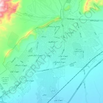
Name: Shahrud topographic map, elevation, terrain.
Location: Shahrud, بخش مرکزی, Shahrud County, Semnan Province, Iran (36.37551 54.91737 36.44660 55.02354)
Average elevation: 1,375 m
Minimum elevation: 1,265 m
Maximum elevation: 1,940 m