
Thank you for supporting this site ❤️
Make a donation
Make a donation
Gear up for your next adventure:
As an Amazon Associate, this site earns from qualifying purchases at no extra cost to you.
Karaj Central District topographic map
Click on the map to display elevation.
Thank you for supporting this site ❤️
Make a donation
Make a donation
Gear up for your next adventure:
As an Amazon Associate, this site earns from qualifying purchases at no extra cost to you.
About this map
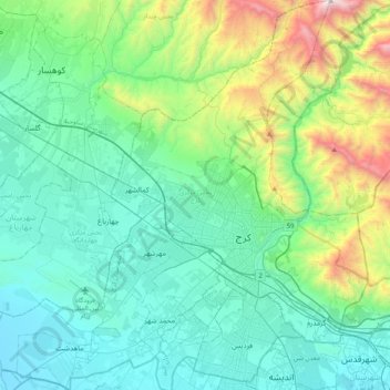
Name: Karaj Central District topographic map, elevation, terrain.
Location: Karaj Central District, Karaj County, Alborz Province, Iran (35.69388 50.72922 36.02048 51.11879)
Average elevation: 1,573 m
Minimum elevation: 1,133 m
Maximum elevation: 3,350 m
Thank you for supporting this site ❤️
Make a donation
Make a donation
Gear up for your next adventure:
As an Amazon Associate, this site earns from qualifying purchases at no extra cost to you.