
بخش همایجان topographic map
Interactive map
Click on the map to display elevation.
About this map
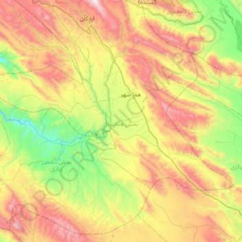
Name: بخش همایجان topographic map, elevation, terrain.
Location: بخش همایجان, Sepidan County, Fars Province, 73641-51638, Iran (29.92095 51.76740 30.19485 52.32131)
Average elevation: 2,111 m
Minimum elevation: 1,384 m
Maximum elevation: 3,220 m
Other topographic maps
Click on a map to view its topography, its elevation and its terrain.
Ardakan
Iran > Fars Province > Sepidan County
Ardakan, بخش مرکزی, Sepidan County, Fars Province, Iran
Average elevation: 2,339 m